Other ID: OC339
Status: Completed
Organization(s): USGS, Woods Hole Coastal and Marine Science Center
Funding Program(s):
Principal Investigator(s): Marinna Martini
Affiliate Investigator(s): Ron Schlitz - NOAA National Marine Fisheries Service, Woods Hole
Information Specialist(s): Frances Lightsom
Data Type(s): Location-Elevation: Navigation, Time Series: Mooring (physical oceanography)
Scientific Purpose/Goals: Deploy moorings and tripods #555 through 567 on Georges Bank at Sites 1 through 7.
Vehicle(s):
Start Port/Location: Woods Hole, MA
End Port/Location: Woods Hole, MA
Start Date: 1999-03-17
End Date: 1999-03-25
Equipment Used: GPS (wh), Bottom platform
Information to be Derived: Time series data;
Summary of Activity and Data Gathered: Moorings deployed: 13 (#555, 556, 557, 558, 559, 560, 561, 562, 563, 564, 565, 566 and 567, all recovered FA 99004 EDWIN LINK Jun. 14-23, 1999).
Staff: Robert Barton, Jonathan Borden, Jessica M. Cote, Raymond E. Davis, Jason Hyatt, Marinna Martini, Joseph S. Newell, William J. Strahle
Affiliate Staff:
Ron Schlitz
Jim Manning
Keston Smith - NMFS; Brian Guest
Laura Goepfert - WHOI; Gregory Lough
Elizabeth Broughton
Antonie Chute
Marie Kaladis - NOAA; Malinda Sutor
Linda DeSousa - URI; Jennifer Elliott - Mass. Maritime Academy
Notes: Deploy mooring numbers 555-567. Original Center People field contained: At sea: Marinna Martini, Jonathan Borden, Jason Hyatt, Jessica Cote; Shoreside mobilization: Marinna Martini, Jonathan Borden, Jessica Cote, Joseph Newell (painting, welding and loading), Robert Barton (loading), Raymond Davis and William Strahle (new tripod design).
Project = Globec, Globec
Location:
Georges Bank, United States, North America, North Atlantic,
| Boundaries | |||
|---|---|---|---|
| North: 41.22710133 | South: 41.03194538 | West: -67.34040934 | East: -67.19757375 |
Platform(s):
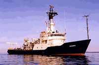
 Oceanus |
| Survey Equipment | Survey Info | Data Type(s) | Data Collected |
|---|---|---|---|
| GPS (wh) | --- | Navigation | |
| Bottom platform | --- | Mooring (physical oceanography) | 1999-003-FA-OM-001 (Globec mooring data) |