Other ID: IB S-2-01-SC
Status: Completed
Organization(s): USGS, Woods Hole Coastal and Marine Science Center
Funding Program(s):
Principal Investigator(s): Jonathan Borden
Affiliate Investigator(s): George Robertson, Orange County Sanitation Department
Information Specialist(s): Frances Lightsom
Data Type(s): Location-Elevation: Navigation, Sampling: Geology, Time Series: Mooring (physical oceanography)
Scientific Purpose/Goals: Set moorings #650 to 659.
Vehicle(s):
Start Port/Location: San Diego, CA
End Port/Location: San Diego, CA
Start Date: 2001-06-11
End Date: 2001-06-14
Equipment Used: Bottom platform, DGPS, Sample containers, Sediment traps
Information to be Derived:
Summary of Activity and Data Gathered: Moorings deployed: 12 (#650, 651, 652, 653, 654, 656, 658 (partial), 659, NPSMET, and NPSTRBM all recovered FA 01050 SPROUL Oct. 11-14, 2001; #655, 657 and 658 (partial) recovered FA 01081 SPROUL Oct. 28 - Nov. 2, 2001).
Staff: Jonathan Borden, Joseph S. Newell, Andree Ramsey, Richard Rendigs
Affiliate Staff:
Marlene Noble (Ch. Sci.)
Joanne Theide-Ferreira
David Gonzales
Hal Williams - all from Menlo Park
Notes: Original Center People field contained: Field Ops: Jonathan Borden, Andree Ramsey, Richard Rendigs; Shipping: Joseph Newell.
Project = Huntington Beach, Huntington Beach
Location:
Orange County, southern California, United States, North America, North Pacific;
| Boundaries | |||
|---|---|---|---|
| North: 33.63863258 | South: 33.56644552 | West: -118.04359807 | East: -117.94929433 |
Platform(s):
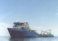 Robert Gordon Sproul |
| Survey Equipment | Survey Info | Data Type(s) | Data Collected |
|---|---|---|---|
| Bottom platform | --- | Mooring (physical oceanography) | 2001-021-FA-OM-001 (mooring data) |
| DGPS | --- | Navigation | |
| Sample containers | --- | Biology Geology | |
| Sediment traps | --- | Geology |
