Other ID: none
Status: Completed
Organization(s): USGS, Woods Hole Coastal and Marine Science Center
Funding Program(s): Other (Other)
Principal Investigator(s): Jane Denny
Affiliate Investigator(s): Jeff Deacon, NH/VT WRD
Information Specialist(s): Jane Denny
Data Type(s): Imagery: Photo, Imagery: Video, Location-Elevation: Navigation, Sampling: Geology, Seismics: Sub Bottom Profiler, Sonar: Interferometric, Sonar: Sidescan, Sonar: Sound Velocity
Scientific Purpose/Goals: Sea floor mapping of Lake Winnipesaukee working with NH WRD; invasive species mapping project.
Vehicle(s):
Start Port/Location: Moultonborough Bay, NH
End Port/Location: Moultonborough Bay, NH
Start Date: 2005-07-23
End Date: 2005-07-30
Equipment Used: Sensor - SVP, Klein 3000, EdgeTech 424 chirp sub-bottom profiler, HYPACK, SeaBOSS, SEA SWATHplus-M 234 kHz
Information to be Derived: Geologic framework of Moultonborough Bay, Lake Winnipesaukee, NH.
Summary of Activity and Data Gathered: Geophysical survey was conducted within Moultonborough Bay, Lake Winnipesaukee using high-resolution sidescan-sonar, swath bathymetry, and chirp sub-bottom profiler. Sediment samples, video and bottom photographs were collected to ground truth the geophysics. These data will lay the foundation for further habitat studies within the Bay.
Staff: William Danforth, Jane Denny, Barry Irwin, Charles Worley
Affiliate Staff:
Notes: Dates have changed from initial pre-cruise report.
Location:
Lake Winnipesaukee, Moultonborough, Carroll County, New Hampshire, United States, North America;
| Boundaries | |||
|---|---|---|---|
| North: 43.72899 | South: 43.70198 | West: -71.34943 | East: -71.39117 |
Platform(s):
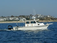
 Rafael |
Argue, D.M., Kiah, R.G., Denny, J.F., Deacon, J.R., Danforth, W.W., Johnston, C.M., and Smagula, A.P., 2007, Relation of lake-floor characteristics to the distribution of variable leaf Water-Milfoil in Moultonborough Bay, Lake Winnipesaukee, New Hampshire, 2005: U.S. Geological Survey Scientific Investigations Report 2007-5125, https://doi.org/10.3133/sir20075125.
Denny, J. F, Danforth, W.W., Worley, C.R., and Irwin, B.J., 2014, High-resolution geophysical and sample data collected in Moultonborough Bay, Lake Winnipesaukee, New Hampshire in 2005, USGS Field Activity 2005-004-FA: U.S. Geological Survey data release, https://doi.org/10.5066/F71N7Z4H.
| Survey Equipment | Survey Info | Data Type(s) | Data Collected |
|---|---|---|---|
| Sensor - SVP | This system is used to acquire the speed of sound within the water column. | Sound Velocity | 2005-004-FA_SVP (Sound velocity profile locations collected by the USGS in Moultonborough Bay, Lake Winnipesaukee, New Hampshire in 2005 (Geographic, WGS 84, Esri point shapefile, CSV file and JPEG image formats)) |
| Klein 3000 | This system acquires acoustic backscatter data (frequencies nominally of 100 and 500 kHz). | Sidescan | 2005-004-FA_sonartrk (Klein 3000 sidescan-sonar survey tracklines collected by the USGS in Moultonborough Bay, Lake Winnipesaukee, New Hampshire in 2005 (Geographic, WGS 84, Esri polyline shapefile and CSV file formats)) Winni_Sonar.tif (1-meter per pixel sidescan-sonar mosaic collected by the USGS in Moultonborough Bay, Lake Winnipesaukee, New Hampshire in 2005 (UTM Zone 19N, WGS 84 GeoTIFF image format)) |
| EdgeTech 424 chirp sub-bottom profiler | This system acquires chirp sub-bottom data (4 to 24 kHz). | Sub Bottom Profiler | 2005-004-FA_chimages (Images of chirp subbottom profiler data collected by the USGS in Moultonborough Bay, Lake Winnipesaukee, New Hampshire in 2005 (JPEG image format. EXIF headers have been modified to include navigation and other meta tags)) 2005-004-FA_chirptrk (Survey tracklines of chirp subbottom data collected by the USGS in Moultonborough Bay, Lake Winnipesaukee, New Hampshire in 2005 (Geographic, WGS 84, Esri polyline shapefile file format)) 2005-004-FA_chirpsht (Unique shot point navigation for Edgetech SB-424 chirp subbottom profiler data collected by the USGS in Moultonborough Bay, Lake Winnipesaukee, New Hampshire in 2005 (Geographic, WGS 84, Esri point shapefile and CSV file formats)) |
| HYPACK | These are the navigation data acquired during survey operations and stored in HYPACK raw format. | Navigation | 2005-004-FA_Hypack (Text files of the Wide Area Augmentation System (WAAS) navigation collected by the USGS in Moultonborough Bay, Lake Winnipesaukee, New Hampshire in 2005 (Geographic, WGS 84, HYPACK ASCII text file formats)) |
| SeaBOSS | This system is used to acquire van veen grab samples of surface sediment, digital video and photographs of the seafloor surface. | Surveys (biological) Experiments (biological) Species ID Photo Video Geology Biology | 2005-004-FA_samples (Sediment samples and textural properties at 40 sample locations collected by the USGS in Moultonborough Bay, New Hampshire in 2005 (Geographic, WGS 84, Esri point shapefile and CSV file formats)) 2005-004-FA_videotrk (Trackline navigation for video data from 40 sample locations collected by the USGS in Moultonborough Bay, New Hampshire in 2005 (Geographic, WGS 84, Esri polyline shapefile and CSV file formats)) 2005-004-FA_bottomphotos (Images of bottom photographs collected by the USGS in Moultonborough Bay, New Hampshire in 2005 (JPEG image file formats. EXIF headers have been modified to include navigation and other meta tags)) 2005-004-FA_photolocs (Locations of bottom photographs collected by the USGS in Moultonborough Bay, New Hampshire in 2005 (Geographic, WGS 84, Esri point shapefile)) |
| SEA SWATHplus-M 234 kHz | This system is used to acquire swath bathymetry and acoustic backscatter. | Interferometric | 2005-004-FA_winni_bathy (1-meter swath bathymetric grid collected by the USGS in Moultonborough Bay, Lake Winnipesaukee, New Hampshire in 2005 (UTM Zone 19N, WGS 84, Esri Binary Grid file format)) 2005-004-FA_bathytrk (Survey tracklines of swath bathymetry collected by the USGS in Moultonbourough Bay, Lake Winnipesaukee, New Hampshire in 2005 (Geographic, WGS 84, Esri polyline shapefile and CSV file formats)) |