Other ID: none
Status: Completed
Organization(s): USGS, Woods Hole Coastal and Marine Science Center
Funding Program(s):
Principal Investigator(s): Wayne Baldwin, William Schwab
Affiliate Investigator(s):
Information Specialist(s): Seth Ackerman, Brian Buczkowski
Data Type(s): Biological Field Study: Experiments (biological), Biological Field Study: Surveys (biological), Imagery: Photo, Imagery: Video, Sampling: Biology, Sampling: Geology, Visual Identification: Species ID, Location-Elevation: Navigation
Scientific Purpose/Goals: Collect bottom photography and sediment samples to validate geophysical data.
Vehicle(s):
Start Port/Location: Woods Hole, MA
End Port/Location: Woods Hole, MA
Start Date: 2010-09-08
End Date: 2010-09-15
Equipment Used: SeaBOSS, DGPS
Information to be Derived: Grain size analysis; Sea floor map;
Summary of Activity and Data Gathered: SeaBOSS grab samples, photos/video for ground truth of high-resolution geophysical data. Sediment grab samples, photos, and video data collected.
Staff: Seth Ackerman, Emile Bergeron, Dann Blackwood, Brian Buczkowski
Affiliate Staff:
Notes:
Project = Massachusetts Coastal Zone Management (MA CZM) Seafloor Mapping - Buzzards Bay and Vineyard Sound, Massachusetts Coastal Zone Management (MA CZM) Seafloor Mapping - Buzzards Bay and Vineyard Sound
Location:
Middle Ground, Vineyard Sound, Marthas Vineyard, Massachusetts, United States, North America, North Atlantic,
| Boundaries | |||
|---|---|---|---|
| North: 41.62776 | South: 41.34795 | West: -71.0156 | East: -70.46082 |
Platform(s):
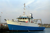
 Connecticut |
Ackerman, S.D., Pappal, A.L., Huntley, E.C., Blackwood, D.S., and Schwab, W.C., 2015, Geological sampling data and benthic biota classification—Buzzards Bay and Vineyard Sound, Massachusetts: U.S. Geological Survey Open-File Report 2014–1221, 30 p., https://doi.org/10.3133/ofr20141221.
Poppe, L.J., McMullen, K.Y., Ackerman, S.D., Blackwood, D.S., Irwin, B.J., Schaer, J.D., and Forrest, M.R., 2011, Sea-floor geology and character of eastern Rhode Island Sound west of Gay Head, Massachusetts: U. S. Geological Survey Open-File Report 2011-1004, DVD-ROM, https://doi.org/10.3133/ofr20111004.
FAN 2010-005-FA has data viewable in the CMGP Video and Photograph Portal. View the data in this application here. See the instructions for working with this application.
| Survey Equipment | Survey Info | Data Type(s) | Data Collected |
|---|---|---|---|
| SeaBOSS | --- | Surveys (biological) Experiments (biological) Species ID Photo Video Geology Biology | 2010-005-FA-PH-002 (photos of deck operations) |
| DGPS | --- | Navigation |