Other ID: none
Status: Completed
Organization(s): USGS, Woods Hole Coastal and Marine Science Center
Funding Program(s): Other (Other)
Principal Investigator(s): Jeffrey List, John Warner
Affiliate Investigator(s): George Voulgaris, University of South Carolina
Information Specialist(s): Ellyn Montgomery
Data Type(s): Location-Elevation: Navigation
Scientific Purpose/Goals: Recover ~7 moorings and ~12 tripods
Vehicle(s):
Start Port/Location: Woods Hole, MA
End Port/Location: Woods Hole, MA
Start Date: 2014-05-02
End Date: 2014-05-09
Equipment Used: DGPS
Information to be Derived: Time series data;Suspended sediment concentrations;
Summary of Activity and Data Gathered: Recovered moorings and tripods
Staff: Dann Blackwood, Jonathan Borden, Patrick Dickhudt, Marinna Martini, Ellyn Montgomery, Christine Sabens, Ilgar Safak, Steven Suttles, John Warner, Charles Worley
Affiliate Staff:
Notes: This is the recovery cruise associated with 2014-004-FA. The time-series data collected is described there. The published data is available at: http://doi.org/10.5066/F7GH9G0B
Location:
Fire Island, NY
| Boundaries | |||
|---|---|---|---|
| North: 40.65251 | South: 40.61187 | West: -73.287 | East: -73.15796 |
Platform(s):
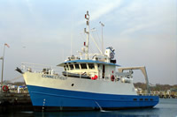
 Connecticut |
| Survey Equipment | Survey Info | Data Type(s) | Data Collected |
|---|---|---|---|
| DGPS | --- | Navigation |