Other ID: none
Status: Completed
Organization(s): USGS, Woods Hole Coastal and Marine Science Center
Funding Program(s): Barrier Evolution (MN00F1F)
Principal Investigator(s): Christopher Sherwood
Affiliate Investigator(s):
Information Specialist(s): Ellyn Montgomery
Data Type(s): Location-Elevation: Navigation, Time Series: Mooring (physical oceanography)
Scientific Purpose/Goals: Recover nanopod (1081) off Sandwich Town Neck Beach.
Vehicle(s):
Start Port/Location: Woods Hole, MA
End Port/Location: Woods Hole, MA
Start Date: 2017-06-12
End Date: 2017-06-12
Equipment Used: DGPS, Bottom platform
Information to be Derived: time series of currents, waves, pressure
Summary of Activity and Data Gathered: Recovered nanopod mooring 1081, divers clipped into lifting bridle with line and float. Inspected waverider mooring 1081, cleaned the buoy, dove to termination of bungy cord, determined the small midwater float is still present. Tried to talk to the release, got no response to enable, disable and release.
Staff: Dann Blackwood, Jonathan Borden, Michael Casso, Eric Marsjanik, Marinna Martini
Affiliate Staff:
Notes:
Associated with 2016-052-FA, 2017-007-FA, 2017-001-FA, 2017-012-FA, 2017-013-FA, 2017-019-FA, 2017-025-FA, 2017-037-FA, 2017-040-FA.
The data for all is available at http://dx.doi.org/10.5066/F7B27T6P.
Location:
Sandwich Town Neck Beach, Cape Cod Bay, Massachusetts, United States, Atlantic Ocean
| Boundaries | |||
|---|---|---|---|
| North: 41.78503467 | South: 41.73478262 | West: -70.4908 | East: -70.42205817 |
Platform(s):
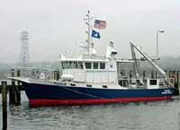
 Tioga |
Sherwood, C.R., Montgomery, E.T., Suttles, S.E. Marsjanik, E.D. and Brosnahan, S.M., 2017, Oceanographic, atmospheric and water-quality measurements Sandwich Town Neck Beach, Massachusetts, 2017, U.S. Geological Survey data release, https://doi.org/10.5066/F7B27T6P.
| Survey Equipment | Survey Info | Data Type(s) | Data Collected |
|---|---|---|---|
| DGPS | --- | Navigation | |
| Bottom platform | --- | Mooring (physical oceanography) |