Other ID: none
Status: Completed
Organization(s): Other, USGS, St. Petersburg Coastal and Marine Science Center
Funding Program(s):
Principal Investigator(s): Richard Poore
Affiliate Investigator(s):
Information Specialist(s): Julie Richey
Data Type(s): Sampling: Geology
Scientific Purpose/Goals: Coring Garrison and Fisk Basins (Gulf of America (Gulf of Mexico)) for paleoceanographic reconstruction
Vehicle(s):
Start Port/Location:
End Port/Location:
Start Date: 2010-04-11
End Date: 2010-04-20
Equipment Used: Box Corer
Information to be Derived: Box cores
Summary of Activity and Data Gathered:
Staff: Jennifer Flannery, Lisa Osterman, Richard Poore, Caitlin Reynolds, Julie Richey
Affiliate Staff:
Notes:
Location:
Garrison and Fisk basins, Northern Gulf of America (Gulf of Mexico)
| Boundaries | |||
|---|---|---|---|
| North: 29.16921796 | South: 25.9902237 | West: -94.3889 | East: -83.55588007 |
Platform(s):
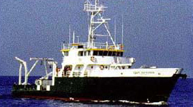
 Cape Hatteras |
Thirumalai, K., Richey, J.N., Quinn, T.M., 2021, Holocene Evolution of SeaâSurface Temperature and Salinity in the Gulf of Mexico: Paleoceanography and Paleoclimatology, Paleoceanogr Paleoclimatol, v. 36 no. 8, doi: 10.1029/2021PA004221.
Thirumalai, K., Richey, J.N., Quinn, T.M., Reynolds, C.E., 2021, Holocene sea-surface temperature and salinity in the Gulf of Mexico: U.S. Geological Survey data release, https://doi.org/10.5066/P9Q5L9VU.
Thirumalai, K., Richey, J.N., Quinn, T.M., Poore, R.Z., 2014, Globigerinoides ruber morphotypes in the Gulf of Mexico: A test of null hypothesis: Scientific Reports, v. 4, doi: 10.1038/srep06018.
| Survey Equipment | Survey Info | Data Type(s) | Data Collected |
|---|---|---|---|
| Box Corer | --- | Biology Geology | Foram_geochemistry.zip (This file contains the downcore Mg/Ca, δ18O and δ13C measurements for the Garrison Basin (.xlsx, .csv)) Radiocarbon_dates.zip (northwestern Gulf of Mexico sediment core 2010-GB2-GC1 collected from the Garrison Basin (26.67°N, 93.92°W) at a water depth of 1776 meters (m), aboard the R/V Cape Hatteras in April 2010. This file contains the 14 raw radiocarbon dates that were used to generate the age model for this sediment core (.xlsx, .csv)) |