Other ID: none
Status: Completed
Organization(s): USGS, St. Petersburg Coastal and Marine Science Center
Funding Program(s):
Principal Investigator(s): Mark Erik Hansen
Affiliate Investigator(s):
Information Specialist(s): Dana Wiese
Data Type(s): Location-Elevation: Transects, Sonar: Interferometric, Sonar: Multibeam
Scientific Purpose/Goals: To collect bathymetric data
Vehicle(s):
Start Port/Location: St. Petersburg, FL
End Port/Location: St. Petersburg, FL
Start Date: 2011-05-09
End Date: 2011-05-13
Equipment Used: Interferometric Bathymetry System, F190 DGPS/IMU
Information to be Derived: Subbottom information
Summary of Activity and Data Gathered:
Staff: William Pfeiffer, Billy Reynolds, Dana Wiese
Affiliate Staff:
Notes:
Location:
Lemon Bay, Florida
| Boundaries | |||
|---|---|---|---|
| North: 26.96836449 | South: 26.93461886 | West: -82.4001 | East: -82.3451197 |
Platform(s):
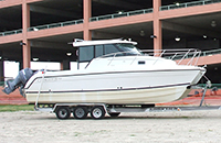
 Glacier Bay Cat Boat |
Hansen, M.E., DeWitt, N.T., Reynolds, B.J., 2017, Archive of bathymetry data collected in South Florida from 1995 to 2015: U.S. Geological Survey Data Series 1031, https://doi.org/10.3133/ds1031.
| Survey Equipment | Survey Info | Data Type(s) | Data Collected |
|---|---|---|---|
| Interferometric Bathymetry System | --- | Interferometric | |
| F190 DGPS/IMU | --- | Navigation |