Other ID: 939009, Phase I Leg D; K-3-69-GM
Status: Completed
Organization(s): USGS, Woods Hole Coastal and Marine Science Center
Funding Program(s):
Principal Investigator(s): Louis E. Garrison
Affiliate Investigator(s): Herb Eppert - NAVOCEANO
Information Specialist(s):
Data Type(s): Location-Elevation: Navigation, Seismics: Air Gun / Water Gun, Seismics: Sparker, Sonar: Single Beam
Scientific Purpose/Goals:
Vehicle(s):
Start Port/Location: Galveston, TX
End Port/Location: New Orleans, LA
Start Date: 1969-03-29
End Date: 1969-04-22
Equipment Used: Air gun, Loran-A, Loran-C, Omega navigation, Magnavox satellite positioning system, Sextant, Sparker , Single channel hydrophone, Echosounder
Information to be Derived: Morphology;
Summary of Activity and Data Gathered: Daily Log #6.
Staff: Louis E. Garrison, Jack Lee
Affiliate Staff:
NAVOCEANO: Herb Eppert - Ch. Sci.
Jack Walker - 9310
Rusty Massengill - 9310
Frank ? - ET
Ernie Walters - ET
Bill Stevens - PST
Dave Rigor - Nav.
Sam Walker - Nav.
Bill Morton - 9310
Bob Bergantino - 9310
Tom Hammon - Ch. ET
Henry Philips - ET
Henry ? - ET
Jim Brown - ET
Bill Johnson - Nav.
Jerry ? - Nav.; Teledyne: Roy Estrellas
Buddy Smith
Johnny Rowe
Notes: Original Center People field contained: Louis Garrison, Jack Lee (off at Tampa).
Project = USGS-NAVOCEANO, USGS-NAVOCEANO
Location:
Gulf of America (Gulf of Mexico), United States, Mexico, North America, North Atlantic;
| Boundaries | |||
|---|---|---|---|
| North: 29.93 | South: 20.84 | West: -96.62 | East: -80.45 |
Platform(s):
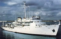 Elisha Kane |
| Title | Survey Equipment | Description |
|---|---|---|
| Cruise log | (document not focused on specific equipment) | Chief Scientist's daily log of data collection, equipment notes, ship movement, etc. |
| Survey Equipment | Survey Info | Data Type(s) | Data Collected |
|---|---|---|---|
| Air gun | --- | Air Gun / Water Gun | |
| Loran-A | --- | Navigation | |
| Loran-C | --- | Navigation | 1969-005-FA-LN-001 (Navigation data in InfoBank) 1969-005-FA-LN-002 (Conglomerate track map for Gulf of Mexico cruises A, B, C and D.) |
| Omega navigation | --- | Navigation | |
| Magnavox satellite positioning system | --- | Navigation | |
| Sextant | --- | Navigation | |
| Sparker | --- | Sparker | |
| Single channel hydrophone | --- | Air Gun / Water Gun Boomer Bubble Gun Sparker Sub Bottom Profiler | 1969-005-FA-SE-002 (analog tape of seismic data) 1969-005-FA-SE-001 (Collection of paper record displays of seismic data (sparker) for lines D-1 thru D-29.) 1969-005-FA-SE-001-01 (Electronic scans of some paper seismic profiles.) |
| Echosounder | --- | Single Beam | 1969-005-FA-BA-001 (Bathymetric data in InfoBank) NGDC MGD77 data |
