Other ID: FAY 020
Status: Completed
Organization(s): USGS, Woods Hole Coastal and Marine Science Center
Funding Program(s):
Principal Investigator(s): Kim D. Klitgord
Affiliate Investigator(s):
Information Specialist(s):
Data Type(s): Electro-Magnetic: Gravity, Location-Elevation: Navigation, Seismics: Air Gun / Water Gun, Seismics: Boomer, Seismics: Sparker, Sonar: Single Beam
Scientific Purpose/Goals: Primary objectives were to look for geophysical evidence for the continuation of fracture zones from the Mesozoic sea-floor spreading anomalies into the continental margin, investigate the source of lineated magnetic anomalies in the Jurassic Quiet Zone, and obtain additional seismic data on the continental rise and slope.
Vehicle(s):
Start Port/Location: Norfolk, VA
End Port/Location: Woods Hole, MA
Start Date: 1976-08-10
End Date: 1976-08-24
Equipment Used: Gravity meter (wh), Seismic Engineering streamer, Air gun, Western Geophysical Integrated Navigation System, Echosounder
Information to be Derived: Morphology;
Summary of Activity and Data Gathered: FAYs depature from Norfolk was delayed for 2 days while Hurricane Belle passed just off the coast. We finally departed at 0800 on August 10th with good weather and calm seas. Airgun, magnetometer, minisparker and 3.5 kHz were deployed at 1900Z near the edge of the continental shelf. The 3.5 kHz proved almost worthless in deep water, so after a few hours the system was turned off and the recorder used as a spare for the airgun system. The other systems ran smoothly for the entire cruise with only brief shutdowns of the airgun system to fix the guns and of the minisparker for regular maintenance. Heading into port on August 24th, we pulled the airgun and magnetometer at the 50 fathom contour but left the minisparker out as we crossed part of Nantucket Shoals. The only major problem was the high noise level on the Geometric gradiometer. Scatter in field readings (+/-2 gammas) made small gradients in the quiet zone impossible to see. The bottles were examined several times and the depressors adjusted to no avail. It appeared the ship has a rather large permanent magnetic field. Problems with LORAN-C reception were eliminated by replacing the corroded terminal box. Gravity: 3950 km; Airgun: 3700 km; Magnetics: 3700 km; Minisparker: 3700 km; 3.5 kHz: 60 km; Sidescan sonar: 0.
Staff: David Egelson, Frank W. Jennings, Kim D. Klitgord, Perry Parks, Phil Shea, Stanley Locker
Affiliate Staff:
Gerard McCarthy - mech. tech.
Rob Pexton - mech. tech.
Claire Reimers - nav. watch
Scott Heald - nav. watch
Lin Morse - seismic watch
Chris Schoen - seismic watch
Kevin King - seismic watch; Paul Bereznak - Western rep.; Hans Schouten - seismic watch
WHOI
Notes: Original Center People field contained: Kim Klitgord - Ch. Sci., Perry Parks - nav./grav. engineer, Frank Jennings - seismic engineer, Gerard McCarthy - mech. tech., Rob Pexton - mech. tech., Phil Shea - mech. tech., David Egelson - nav. watch, Claire Reimers - nav. watch, Scott Heald - nav. watch, Lin Morse - seismic watch, Chris Schoen - seismic watch, Stan Locker - seismic watch, Kevin King - seismic watch.
Location:
Mid-Atlantic Continental Margin, North Atlantic Continental Margin, United States, North America, North Atlantic;
| Boundaries | |||
|---|---|---|---|
| North: 41.5 | South: 32.70308226 | West: -76 | East: -65.47851563 |
Platform(s):
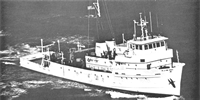
 Fay |
Klitgord, K.D., 1979, Availability of single channel seismic refraction profiles collected over U.S. Atlantic continental slope and rise north of Cape Hatteras - USGS cruises FAY 20 and FAY 21 - August/September, 1976: U.S. Geological Survey Open-File Report 79-578, 4 p., https://doi.org/10.3133/ofr79578.
Paskevich, V.F., and Soderberg, N.K., 1997, Navigation and geophysical data collected onboard the R/V Fay from 1975-1976: U.S. Geological Survey Open-File Report 97-512, CD-ROM, URL: https://doi.org/10.3133/ofr97512.
| Title | Survey Equipment | Description |
|---|---|---|
| Cruise report | (document not focused on specific equipment) | Chief Scientist's cruise summary of ship movement, personnel, and equipment and data acquisition notes. Includes trackmap. Information for field activities 1976-030-FA and 1976-033-FA. |
| Survey Equipment | Survey Info | Data Type(s) | Data Collected |
|---|---|---|---|
| Gravity meter (wh) | --- | Gravity | 1976-030-FA-GP-001 (Digital tape(s) of NV1-10, NV11-16, GR, MG-FINAL, NV,GR,BT-FINAL, GR-FINAL, NV,BT-FINAL, NV-INS, NV-INS-FINAL, ) |
| Seismic Engineering streamer | --- | Air Gun / Water Gun Boomer Sparker | 1976-030-FA-SE-001 ( Collection of paper record displays of seismic data( AIR) for lines ) 1976-030-FA-SE-003 (analog tape of seismic data) image2segy (PCMSC; FAD. Please contact PCMSC_data@usgs.gov with any questions.) 1976-030-FA-SE-002 (microfilm of REPLAYS ADDED FEB 79FOR LINES 1-9, 4-9, 1-10) 1976-030-FA-SE_airgun_scans (TIFF images of airgun paper records. Scanned at 300 DPI, grayscale) 1976-030-FA-SE_airreplay_scans (TIFF images of replays of airgun paper records. Scanned at 300 DPI, grayscale) |
| Air gun | --- | Air Gun / Water Gun | |
| Western Geophysical Integrated Navigation System | --- | Navigation | 1976-030-FA-LN-001-06 (Trackline Map 5 of 5 (pdf file) Trackline map for Aug 23-24, 1976 with dates and hourly fixes.) 1976-030-FA-LN-001-05 (Trackline Map 4 of 5 (pdf file) Trackline map for Aug 16-22, 1976 with dates and hourly fixes.) 1976-030-FA-LN-001-04 (Trackline Map 3 of 5 (pdf file) Trackline for map Aug 12-16, 1976 with dates and hourly fixes.) 1976-030-FA-LN-001-02 (Trackline Map 1 of 5 (pdf file) Trackline map for Aug 14-15, 1976 with dates and hourly fixes.) 1976-030-FA-LN-001-03 (Trackline Map 2 of 5 (pdf file) Trackline map for Aug 11-12, 1976 with dates and hourly fixes.) 1976-030-FA-LN-001-01 (Trackline Map for FAY 020 and 021 (pdf file) Composite trackline map for cruises FAY 020 and 021 with dates, hourly fixes, and line numbers. ) 1976-030-FA-LN-002-01 (Navigation files for various 1975-1976 R/V Fay cruises as published in USGS OFR 97-512.) |
| Echosounder | --- | Single Beam | 1976-030-FA-BA-001 (Digital tape(s) of NV1-10, NV11-16, GR, MG-FINAL, NV,GR,BT-FINAL, GR-FINAL, NV,BT-FINAL, NV-INS, NV-INS-FINAL, ) |