Other ID: none
Status: Completed
Organization(s): USGS, Woods Hole Coastal and Marine Science Center
Funding Program(s):
Principal Investigator(s): Phil Shea
Affiliate Investigator(s):
Information Specialist(s):
Data Type(s): Time Series: Mooring (physical oceanography)
Scientific Purpose/Goals: Deploy and recover mooring #112 nearby SEDCO-J semi-submersible COST oil rig on Georges Bank.
Vehicle(s):
Start Port/Location:
End Port/Location:
Start Date: 1976-05-21
End Date: 1976-05-26
Equipment Used: Bottom platform
Information to be Derived: Time series data;
Summary of Activity and Data Gathered: Mooring deployed and recovered: 1 (#112).
Staff: Phil Shea
Affiliate Staff:
Notes:
Location:
Georges Bank, United States, North America, North Atlantic,
| Boundaries | |||
|---|---|---|---|
| North: 40.89828997 | South: 40.67924788 | West: -67.5335636 | East: -67.259313 |
Platform(s):
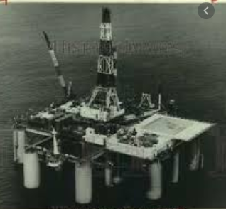 Sedco-J |
| Survey Equipment | Survey Info | Data Type(s) | Data Collected |
|---|---|---|---|
| Bottom platform | --- | Mooring (physical oceanography) | 1976-050-FA-OM-001 (Georges Bank Sediment mooring data) |
