Other ID: 78-1, 78-2
Status: Completed
Organization(s): USGS, Woods Hole Coastal and Marine Science Center
Funding Program(s):
Principal Investigator(s): John M. Aaron
Affiliate Investigator(s):
Information Specialist(s):
Data Type(s): Imagery: Photo, Imagery: Video, Location-Elevation: Navigation, Sampling: Geology, Seismics: Sparker, Seismics: Sub Bottom Profiler, Visual Identification: Submersible Observations
Scientific Purpose/Goals: Make detailed observations of geologic hazards, especially slumping, along the upper continental slope off Georges Bank and off Baltimore Canyon area.
Vehicle(s):
Start Port/Location: Cape May, NJ
End Port/Location: Woods Hole, MA
Start Date: 1978-07-30
End Date: 1978-08-09
Equipment Used: Video camera - deep sea, ORE 140 transceiver/1036 transducer sub-bottom profiler, Benthos model 372 camera and strobe, Van Veen grab sampler, Teledyne single-channel 300-500J 40-tip minisparker, Northstar 6000 LORAN-C, Single channel hydrophone, Submersible Observation
Information to be Derived:
Summary of Activity and Data Gathered: DIAPHUS dives: 24; Minisparker: 592 km; 3.5 kHz: 15 km; Van Veen grab samples: 6; Video tapes; Photos.
Staff: John M. Aaron, Susan Barton, Cynthia Bryden, John C., Jr. Hampson, Jerry McCarthy, Richard E. Sylwester, David Twichell
Affiliate Staff:
Rich Slater - Ch. Sci.; Pam Butler - guest
Reader's Digest; Charles V. G. Phipps - guest
University of Sydney
Australia; Don Bolstad - diving operation supervisor
Martek; Gordon Barksdale - pilot
Martek; Pat Hickey - pilot
Martek
Notes: Original Center People field contained: Rich Slater - Ch. Sci.; John Aaron - geologist, North Atlantic; Cynthia Bryden - biologist; Jack Hampson - geological assistant; Jerry McCarthy - tech.; Susan Purdy - secretary; Dick Sylwester - tech.; Dave Twichell - geologist, Mid-Atlantic.
Location:
South Toms Canyon, Carteret Canyon, Baltimore Canyon Trough, Georges Bank, Veatch Canyon, Lydonia Canyon, North Atlantic upper Continental Slope, United States, North America, North Atlantic;
| Boundaries | |||
|---|---|---|---|
| North: 41.5 | South: 38.8 | West: -75 | East: -67.5 |
Platform(s):
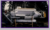 Diaphus |  State Arrow |
| Title | Survey Equipment | Description |
|---|---|---|
| Cruise report | (document not focused on specific equipment) | Cruise report listing personnel, equipment, seismic operational summary, submersible dive logs, and track map including sparker surveys and dive areas. |
| Data log | (document not focused on specific equipment) | Log book specifying data associated with recording media, grab sample locations and notes, submersible dives - locations and observers. |
| Survey Equipment | Survey Info | Data Type(s) | Data Collected |
|---|---|---|---|
| Video camera - deep sea | --- | Video | |
| ORE 140 transceiver/1036 transducer sub-bottom profiler | --- | Sub Bottom Profiler | 1978-021-FA-BA-001 (Digital tape of BT data: inv. # 0928.) |
| Benthos model 372 camera and strobe | --- | Photo | 1978-021-FA-PH-001 (Bottom photo 35 mm slides: from 19 of 24 dives.) |
| Van Veen grab sampler | --- | Geology | |
| Teledyne single-channel 300-500J 40-tip minisparker | --- | Sparker | |
| Northstar 6000 LORAN-C | --- | Navigation | 1978-021-FA-LN-002 (Digital tape of NV-FINAL data: inv. # 1747.) 1978-021-FA-LN-001 (Navigation trackline plot for field activity 78021) |
| Single channel hydrophone | --- | Air Gun / Water Gun Boomer Bubble Gun Sparker Sub Bottom Profiler | 1978-021-FA-SE-001 ( Collection of paper record displays of seismic data( MSP) for lines ) 1978-021-FA-NL-003-02 (Cruise Curator's inventory and description of sparker and 3.5 kHz seismic data, sample station locations, and submersible dive locations. ) 1978-021-FA-SE-002 (microfilm of *SMALL CAN, NO#) 1978-021-FA-SE-003 (analog tape of seismic data) |
| Submersible Observation | --- | Submersible Observations | 1978-021-FA-NL-002 (Dive audio tapes: original tapes missing as of 09/25/09.) 1978-021-FA-NL-002-01 (Audio tape transcripts and supporting observer notes: from 23 of 24 dives (#5 missing).) |
