Other ID: none
Status: Completed
Organization(s): USGS, Woods Hole Coastal and Marine Science Center
Funding Program(s):
Principal Investigator(s): Bruce Ambuter, Anne M. Trehu
Affiliate Investigator(s):
Information Specialist(s):
Data Type(s): Location-Elevation: Navigation, Seismics: Ocean Bottom Seismometer
Scientific Purpose/Goals: Leg 3 of three cruises compiled on one report, all 1982. LEG 3: 9/14, USCG CAPE HEDGE - Recover 6 OBIP in event detecting mode on the Santa Lucia Bank at SW margin of the Santa Maria Basin. (See related FAs 82024 and 82027.)
Vehicle(s):
Start Port/Location: Morro Bay, CA
End Port/Location: Morro Bay, CA
Start Date: 1982-09-14
End Date: 1982-09-14
Equipment Used: Loran-C, Ocean Bottom Seismometer
Information to be Derived:
Summary of Activity and Data Gathered: 6 OBIPs recovered.
Staff: Raymond E. Davis
Affiliate Staff:
Notes: Three cruise legs compiled on one report, all 1982. LEG 1: 7/14-7/17, R/V ELLEN B. SCRIPPS, FA 82024. LEG 2: 7/26, USCG CAPE WASH, FA 82027. LEG 3: 9/14, USCG CAPE HEDGE, FA 82033.
Location:
Morro Bay, Santa Lucia Bank, Santa Maria Basin, California, United States, North America, North Pacific;
| Boundaries | |||
|---|---|---|---|
| North: 34.85556 | South: 33.60167 | West: -121.469 | East: -119.4 |
Platform(s):
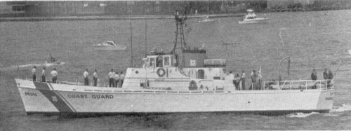 Cape Hedge |
| Title | Survey Equipment | Description |
|---|---|---|
| Cruise report | (document not focused on specific equipment) | Chief Scientist's cruise report including personnel, equipment configuration, data acquisition notes, cruise narrative, seismic shots and locations, OBIP site locations and position maps. This cruise report is also for 1982-024-FA and 1982-027-FA. |
| Survey Equipment | Survey Info | Data Type(s) | Data Collected |
|---|---|---|---|
| Loran-C | --- | Navigation | |
| Ocean Bottom Seismometer | --- | Ocean Bottom Seismometer |
