Other ID: GM 86-06
Status: Completed
Organization(s): USGS, Woods Hole Coastal and Marine Science Center
Funding Program(s):
Principal Investigator(s): Page Valentine
Affiliate Investigator(s):
Information Specialist(s): Page Valentine
Data Type(s): Seismics: Sub Bottom Profiler, Location-Elevation: Navigation
Scientific Purpose/Goals: Bathymetric survey of Corsair Canyon and Georges Bank.
Vehicle(s):
Start Port/Location: Davisville, RI
End Port/Location: Woods Hole, MA
Start Date: 1986-04-20
End Date: 1986-04-24
Equipment Used: 3.5 kHz, Northstar 6000 LORAN-C
Information to be Derived:
Summary of Activity and Data Gathered: Because of adverse weather conditions, the survey was limited to a total of 18.5 hours in Corsair Canyon area. 3.5 kHz data: 167 km.
Staff: David Twichell, Page Valentine, Steve Mateus
Affiliate Staff:
Clifford Newell (NMFS)
Tom Meyer (NMFS)
Notes:
Project = Biostratigraphic and Depositional Framework - U.S. Atlantic Margin, Biostratigraphic and Depositional Framework - U.S. Atlantic Margin
Location:
eastern Georges Bank, Corsair Canyon, United States, North America, North Atlantic;
| Boundaries | |||
|---|---|---|---|
| North: 41.4 | South: 41 | West: -69 | East: -66.21667 |
Platform(s):
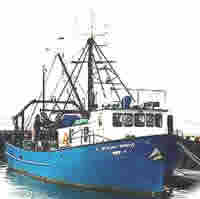
 Gloria Michelle |
| Title | Survey Equipment | Description |
|---|---|---|
| Cruise report | (document not focused on specific equipment) | Chief Scientist's report including personnel, equipment, description, and a trackmap. |
| Survey Equipment | Survey Info | Data Type(s) | Data Collected |
|---|---|---|---|
| 3.5 kHz | --- | Sub Bottom Profiler | |
| Northstar 6000 LORAN-C | --- | Navigation |