Other ID: STRL 87-1
Status: Completed
Organization(s): USGS, Woods Hole Coastal and Marine Science Center
Funding Program(s):
Principal Investigator(s): William Dillon, N. Terence Edgar
Affiliate Investigator(s):
Information Specialist(s): Catherine Delorey
Data Type(s): Electro-Magnetic: Gravity, Electro-Magnetic: Magnetics, Location-Elevation: Navigation, Seismics: Air Gun / Water Gun, Sonar: Single Beam
Scientific Purpose/Goals: To provide further geophysical data to aid the interpretation of a GLORIA survey conducted in the area in October 1985, and to obtain knowledge pertinent to the general structural analysis of the northern boundary of the Caribbean Plate. The GLORIA survey consisted of a grid in the central Cayman Trough and a single swath eastward through the Trough to the Windward Passage.
Vehicle(s):
Start Port/Location: Kingston, Jamaica
End Port/Location: Kingston, Jamaica
Start Date: 1987-01-07
End Date: 1987-01-19
Equipment Used: Air gun, Marine magnetometer, Echosounder, Gravity meter (wh), Starfix navigation system, Single channel hydrophone
Information to be Derived:
Summary of Activity and Data Gathered: The cruise operated in the eastern Cayman Trough, northeast and north of Jamaica, and in the central Cayman Trough, south of the Cayman Islands. The seismic system operated well throughout the cruise, once initial streamer problems were worked out. End points of seismic profiles are indicated in the appendix. A total of 1270 nautical miles (2352 km) of seismic data were collected. The Starfix navigation system worked perfectly throughout the cruise giving excellent results. The gravity system also worked well. Unfortunately, both the magnetometer and seismic tape recorder failed early in the cruise, and, after considerable effort, were found to be unrepairable. The tape recorder had mechanical problems in the tape takeup system. The magnetometer first developed noise due to inadequate fluid in the bottle resulting from a broken pressure-compensating diaphragm. An emergency repair was made by D. Nichols, consisting of removing the diaphragm, sealing the pressure compensation holes in the bottle, and filling it with clean diesel fuel. This worked well and provided excellent, quiet data for about a day. However, further problems developed due to short circuits in the tow cable which were unrepairable. Eastern Cayman Trough Survey: 9 survey lines; Central Cayman Trough Survey: 22 survey lines.
Staff: Catherine Delorey, William Dillon, N. Terence Edgar, David Mason, David Nichols
Affiliate Staff:
R. Diaz
Watch Stander; C. Heywood
Nav.-Grav. Technician (Branch of Pacific Marine Geology); H. Carvajal
Watch Stander and Observer (INGEOMINAS
Colombia); J. Banhan
Watch Stander and Observer (Geological Survey of Jamaica)
Notes: Original Center People field contained: William Dillon, co-Ch. Sci.; Terence Edgar, co-Ch. Sci.; Dave Nichols, Electronics Technician; David Mason, Seismic Technician; C. Delorey, Watch Stander, Cruise Data Curator; R. Diaz, Watch Stander.
Location:
Cayman Trough, Jamaica, Cayman Islands, Caribbean Sea, North America, North Atlantic;
| Boundaries | |||
|---|---|---|---|
| North: 19.2 | South: 17.4 | West: -82.3 | East: -75 |
Platform(s):
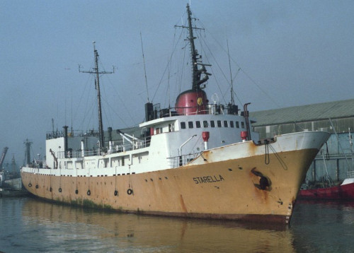
 Starella |
| Title | Survey Equipment | Description |
|---|---|---|
| Cruise report | (document not focused on specific equipment) | Chief Scientist's report including personnel, equipment, narrative, and navigation waypoints. |
| Navigation log | Starfix navigation system | Handwritten navigation log including navigation fixes, start and end of lines and tapes. |
| Geophysics log | Air gun | Air gun log containing start and end of lines and tapes, equipment configuration, data acquisition notes. |
| Survey Equipment | Survey Info | Data Type(s) | Data Collected |
|---|---|---|---|
| Air gun | --- | Air Gun / Water Gun | |
| Marine magnetometer | --- | Magnetics | |
| Echosounder | --- | Single Beam | |
| Gravity meter (wh) | --- | Gravity | 1987-001-FA-GP-001 (Digital tape(s) of GRAV,) |
| Starfix navigation system | --- | Navigation | 1987-001-FA-LN-001 (Navigation trackline plot for field activity 87001) 1987-001-FA-LN-002 (Digital tape(s) of NV, ) |
| Single channel hydrophone | --- | Air Gun / Water Gun Boomer Bubble Gun Sparker Sub Bottom Profiler | 1987-001-FA-SE-001 ( Collection of paper record displays of seismic data( 12K) for lines ) 1987-001-FA-SE-002 (microfilm of ) 1987-001-FA-SE-003 (analog tape of seismic data) |