Other ID: AII 122
Status: Completed
Organization(s): USGS, Woods Hole Coastal and Marine Science Center
Funding Program(s):
Principal Investigator(s): Michael Bothner
Affiliate Investigator(s): J. Fred Grassle, Rutgers University
Information Specialist(s):
Data Type(s): Location-Elevation: Navigation, Sampling: Geology, Sonar: Multibeam, Time Series: Mooring (physical oceanography), Visual Identification: Submersible Observations
Scientific Purpose/Goals: To test the hypothesis that particles from municipal sewage sludge disposal at Deep Water Dump Site 106 can be detected on the deep-sea floor in the vicinity of this dump site (2250-2750 m water depth). USGS objectives were to construct a detailed bathymetric map using SeaBeam (URI), deploy instruments to monitor currents and sediment transport, and collect samples to evaluate rates of sediment mixing and accumulation and levels of chemical contaminants in surficial sediments.
Vehicle(s):
Start Port/Location: Woods Hole, MA
End Port/Location: Woods Hole, MA
Start Date: 1989-09-15
End Date: 1989-09-26
Equipment Used: SeaBeam 2112, Loran-C, Push corer (wh), Bottom platform, Submersible Observation
Information to be Derived: Time series data; Samples and chemical analysis; Grain size analysis; Suspended sediment concentrations; Sea floor map; Bathymetric maps;
Summary of Activity and Data Gathered: Data acquired include a Sea Beam bathymetric map and digitally recorded depth data from a survey area of about 520 nmi2 (or about 1750 km2), sediment samples from gravity cores and Alvin-manipulated corers (some cores were subsampled at sea), and the usual video, camera and audio descriptive data generated by ALVIN. Current-meter and sediment-trap data retrieval tentatively scheduled for OCEANUS cruise in May 1990. Moorings deployed: 2 (#336 and 337 recovered FA 90026 OCEANUS 222 Aug. 2-7, 1990).
Staff: Michael Bothner, Adam Brown, Richard Rendigs, James M. Robb, William J. Strahle
Affiliate Staff:
Ginger Fry; WHOI - Fred Grassle (Ch. Sci.)
Rosemarie Petrecca
Hovey Clifford
Paul Snelgrove
Michael Moore
Elizabeth Garland; UCONN - Bob Whitlatch; Univ. of Maryland - Russel Hill and Ivor Knight; New York Times - Walter Sullivan; NOAA - Michael DeLuca; URI Seabeam group - Joyce Miller and Peter Lemmond
Notes: Original Center People field contained: Mike Bothner, Adam Brown, Ginger Fry, Richard Rendigs, James Robb, William Strahle.
Project = DWD 106 Municipal Sludge Investigation, DWD 106 Municipal Sludge Investigation
Location:
Continental Rise offshore New Jersey, New York, Deep Water Dump Site (DWDS) 106, United States, North America, North Atlantic;
| Boundaries | |||
|---|---|---|---|
| North: 41 | South: 38.5 | West: -72.5 | East: -70.5 |
Platform(s):
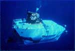 Alvin | 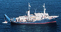 Atlantis II |
Robb, J.M., 1992, Bathymetry of the upper continental rise in the vicinity of a sewage sludge dumpsite near 39° N, 72° W, offshore New Jersey and New York: U.S. Geological Survey Open-File Report 92-375, https://doi.org/10.3133/ofr92375.
Robb, J.M., 1994, Geologic features of the sea bottom around a municipal sludge dumpsite near 39 degrees N., 73 degrees W., offshore New Jersey and New York: U.S. Geological Survey Open-File Report 94-152, https://doi.org/10.3133/ofr94152.
ten Brink, U.S., Barkan, R., Andrews, B.D., and Chaytor, J.D., 2009, Size distributions and failure initiation of submarine and subaerial landslides: Earth and Planetary Science Letters, v. 287 no. 1-2, doi: 10.1016/j.epsl.2009.07.031.
Twichell, D.C., Chaytor, Jason D., ten Brink, Uri S., and Buczkowski, Brian, 2009, Morphology of late Quaternary submarine landslides along the U.S. Atlantic continental margin: Marine Geology, v. 264 no. 1-2, doi: 10.1016/j.margeo.2009.01.009.
| Title | Survey Equipment | Description |
|---|---|---|
| Cruise report | (document not focused on specific equipment) | Chief Scientist's cruise report including personnel, purpose, equipment, tabulated information, trackmap, locations of Alvin dives, sampling stations, current meter-sediment trap arrays, otter trawl and neuston tows. Also described Seabeam operations and provided the USGS sample list. |
| Survey Equipment | Survey Info | Data Type(s) | Data Collected |
|---|---|---|---|
| SeaBeam 2112 | --- | Multibeam | |
| Loran-C | --- | Navigation | |
| Push corer (wh) | --- | Biology Geology | 1989-027-FA-SC-001 (CORE, SUBMERSIBLE SAMPLE samples) |
| Bottom platform | --- | Mooring (physical oceanography) | 1989-027-FA-OM-001 (Site 106 mooring data) |
| Submersible Observation | --- | Submersible Observations | 1989-027-FA-NL-002 (Audio tape tape for sub dive 2167) |
