Other ID: 91-3
Status: Completed
Organization(s): USGS, Woods Hole Coastal and Marine Science Center
Funding Program(s):
Principal Investigator(s): Page Valentine
Affiliate Investigator(s):
Information Specialist(s):
Data Type(s): Environmental Data: CTD, Environmental Data: Turbidity, Sampling: Chemistry, Sampling: Biology, Sampling: Geology, Sonar: Multibeam, Sonar: Single Beam, Location-Elevation: Navigation
Scientific Purpose/Goals: Collaborative research with USGS, NMFS and Bigelow Lab. Sample water column for physical properties, chlorophyll, nutrients, zooplankton and herring larvae; sample sea floor for texture and herring egg beds; echo sounding and high-resolution seismic profiling for bedform and texture distribution; and map egg bed distribution and relationship to bottom environment.
Vehicle(s):
Start Port/Location: Castine, ME
End Port/Location: Castine, ME
Start Date: 1991-10-01
End Date: 1991-10-13
Equipment Used: SBE 9 CTD, Fluorometer, Niskin bottle, Plankton nets, Dredge, Simrad EM120, ECHOTRAC digital bathymetry system, GPS (wh), Megapulse Accufix 500 LORAN-C
Information to be Derived:
Summary of Activity and Data Gathered:
Staff: Nancy K. Soderberg, Andrew Brill, Eric A. Schmuck
Affiliate Staff:
NMFS: Greg Lough
Betsy Broughton
Alex Penkrat; Bigelow Lab: Jeff Brown
Notes:
Project = EEZ shelf mapping - eastern Georges Bank, EEZ shelf mapping - eastern Georges Bank
Location:
northern edge of Georges Bank, United States, North America, North Atlantic;
| Boundaries | |||
|---|---|---|---|
| North: 42.2 | South: 41.5 | West: -67.9 | East: -67 |
Platform(s):
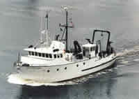
 Argo Maine |
| Title | Survey Equipment | Description |
|---|---|---|
| Cruise report | (document not focused on specific equipment) | Chief Scientist's cruise report including personnel, purpose, equipment, tabulated information, station location and type of sample acquired, maps of station locations. |
| Survey Equipment | Survey Info | Data Type(s) | Data Collected |
|---|---|---|---|
| SBE 9 CTD | --- | CTD | |
| Fluorometer | --- | Turbidity | |
| Niskin bottle | --- | Chemistry | |
| Plankton nets | --- | Biology | |
| Dredge | --- | Biology Geology | |
| Simrad EM120 | --- | Multibeam | |
| ECHOTRAC digital bathymetry system | --- | Single Beam | |
| GPS (wh) | --- | Navigation | |
| Megapulse Accufix 500 LORAN-C | --- | Navigation |