Other ID: ERDA-92-4; 92ER4
Status: Completed
Organization(s): USGS, Woods Hole Coastal and Marine Science Center
Funding Program(s):
Principal Investigator(s): Jack Kindinger
Affiliate Investigator(s):
Information Specialist(s):
Data Type(s): Seismics: Boomer, Seismics: Sub Bottom Profiler, Location-Elevation: Navigation
Scientific Purpose/Goals: Collect continuous, high-resolution seismic reflection profiles in Mississippi Sound.
Vehicle(s):
Start Port/Location:
End Port/Location:
Start Date: 1992-08-16
End Date: 1992-08-20
Equipment Used: GeoPulse uniboom, Single channel hydrophone, GPS (wh), Loran-C
Information to be Derived: Sea floor map;
Summary of Activity and Data Gathered: Seismic reflection profiles: 21 lines.
Staff:
Affiliate Staff:
Jack Kindinger - Ch. Sci. - USGS-St. Pete; Dana Wiese - USGS-St. Pete
Notes: Information from St. Petersburg office.
Project = Mississippi/Alabama Pollution Project, Mississippi/Alabama Pollution Project
Location:
Pascagoula, Mississippi Sound, Biloxi Bay to Mobile Bay, mouth of Horn Island Pass, Mississippi, Dauphin Island, Alabama, United States, Gulf of Mexico, North America, North Atlantic;
| Boundaries | |||
|---|---|---|---|
| North: 30.2 | South: 29.2 | West: -88.8 | East: -88.1 |
Platform(s):
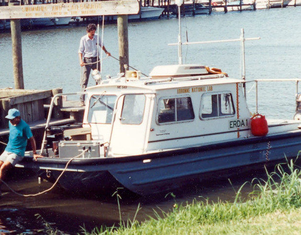 Erda-1 |
Sanford, J.M., Harrison, Arnell S., Wiese, Dana S., and Flocks, James G., 2008, Archive of digitized analog Boomer seismic reflection data collected from Lake Pontchartrain, Louisiana, to Mobile Bay, Alabama, during cruises onboard the R/V ERDA-1, June and August 1992: U.S. Geological Survey Data Series, http://pubs.usgs.gov/ds/370/.
| Survey Equipment | Survey Info | Data Type(s) | Data Collected |
|---|---|---|---|
| GeoPulse uniboom | --- | Boomer | |
| Single channel hydrophone | --- | Air Gun / Water Gun Boomer Bubble Gun Sparker Sub Bottom Profiler | Boomer seismic data |
| GPS (wh) | --- | Navigation | 92ER4 Annotated Navigation Fixes |
| Loran-C | --- | Navigation |
