Other ID: none
Status: Completed
Organization(s): USGS, Woods Hole Coastal and Marine Science Center
Funding Program(s):
Principal Investigator(s): Richard Rendigs
Affiliate Investigator(s):
Information Specialist(s):
Data Type(s): Location-Elevation: Navigation, Sampling: Geology, Imagery: Photo, Imagery: Video, Sonar: Single Beam, Sonar: Sidescan
Scientific Purpose/Goals: Collect bottom samples (grab) and video camera footage at selected sites throughout Long Island Sound for validation of sedimentary environments as determined from a regional USGS sidescan sonar survey in 1995. Selected video camera transects will be utilized to verify transition areas of sedimentary environments within Long Island Sound. A secondary object, if time allowed, was to collect additional sidescan sonar data in areas of Long Island Sound where no data or additional records were required as an adjunct to the 1995 ANDERSON cruise (ANDR 95010).
Vehicle(s):
Start Port/Location: Woods Hole, MA
End Port/Location: Woods Hole, MA
Start Date: 1996-04-11
End Date: 1996-04-17
Equipment Used: SIS1000 Sidescan sonar, DGPS, Van Veen grab sampler, Osprey camera system, Odom Digitrace 200kHz
Information to be Derived: Grain size analysis; Sea floor map;
Summary of Activity and Data Gathered: Grab samples: 129; Video transects: 9.
Staff: Dann Blackwood, Michael Casso, Richard Rendigs, Nancy K. Soderberg, Kenneth F. Parolski, Brenton B. Taylor
Affiliate Staff:
Notes:
Project = Long Island Sound Environmental Studies, Long Island Sound Environmental Studies
Location:
Long Island Sound, Connecticut, New York, United States, North America, North Atlantic;
| Boundaries | |||
|---|---|---|---|
| North: 41.25635915 | South: 40.91720236 | West: -73.56093768 | East: -72.20398843 |
Platform(s):
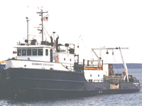 Seaward Explorer |
Poppe, L.J., McMullen, K. Y., Williams, S. J., Crocker, J. M., and Doran, E. F., 2008, Estuarine sediment transport by gravity-driven movement of the nepheloid layer, Long Island Sound: Geo-Marine Letters, v. 28 no. 4, doi: 10.1007/s00367-008-0118-2.
Poppe, L.J., Polloni, C., eds., 1998, Long Island Sound environmental studies: U.S. Geological Survey Open-File Report (98-502), https://doi.org/10.3133/ofr98502.
| Title | Survey Equipment | Description |
|---|---|---|
| Cruise report | (document not focused on specific equipment) | Chief Scientist's cruise report including personnel, purpose, equipment, tabulated information, station locations, cruise summary, map of station locations and camera transects. |
| Survey Equipment | Survey Info | Data Type(s) | Data Collected |
|---|---|---|---|
| SIS1000 Sidescan sonar | Not used on the cruise. | Sidescan | No data was collected |
| DGPS | --- | Navigation | 1996-017-FA-LN-001-01 (Raw GPS navigation data.) |
| Van Veen grab sampler | --- | Geology | 1996-017-FA-SC-001 (GRAB samples) |
| Osprey camera system | --- | Photo Video | |
| Odom Digitrace 200kHz | --- | Single Beam |
