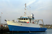
Other ID: none
Status: Completed
Organization(s): USGS, Woods Hole Coastal and Marine Science Center
Funding Program(s):
Principal Investigator(s): Marilyn ten Brink
Affiliate Investigator(s): Johan Varekamp, Wesleyan University
Information Specialist(s): Ellen Mecray, Nancy K. Soderberg
Data Type(s): Imagery: Photo, Imagery: Video, Location-Elevation: Navigation, Sampling: Geology
Scientific Purpose/Goals: To collect grab samples to be used for toxicity tests: 3 grabs per station, 30 stations transiting the Sound from east to west in a zig zag pattern to achieve both along-axis and cross-axis samples. Collaborating scientists from Wesleyan University will also be aboard to sample 10 stations for bottom water and foram samples in sediments.
Vehicle(s):
Start Port/Location: Groton, CT
End Port/Location: Groton, CT
Start Date: 1999-11-08
End Date: 1999-11-11
Equipment Used: Grab sampler, Video camera - deep sea, Digital camera, DGPS
Information to be Derived:
Summary of Activity and Data Gathered: Samples covered most of Long Island Sound.
Staff: Dann Blackwood, Erin Galvin, Ellen Mecray, Joseph S. Newell, Sunita Shah, Marilyn ten Brink
Affiliate Staff:
Wesleyan person - bottom samples and grabs; Joop Varekamp - Assoc. Chief Sci.; Taras Gapotchenko and Joshoa Koch
assistants
Notes: Latitude coordinates are not entered here. Original Center People field contained: Marilyn ten Brink - Chief Scientist; Ellen Mecray, Sunita Shah - deck ops, Erin Galvin - deck ops and mob, Dann Blackwood - video on grab, Joe Newell - mob and transport gear to/from Groton.
Project = Long Island Sound Environmental studies: Geochemistry, Long Island Sound Environmental studies: Geochemistry
Location:
Long Island Sound, New York, Connecticut, United States, North America, North Atlantic,
| Boundaries | |||
|---|---|---|---|
| North: 41.31018 | South: 40.87833 | West: -73.7469 | East: -72.04258 |
Platform(s):
 Connecticut |
| Survey Equipment | Survey Info | Data Type(s) | Data Collected |
|---|---|---|---|
| Grab sampler | --- | Biology Geology | 1999-056-FA-SC-001 (GRAB samples) |
| Video camera - deep sea | --- | Video | |
| Digital camera | --- | Photo | 1999-056-FA-PH-001 (CD ROM disk of CORE PHOTOS LIS, DECK PHOTOS LIS, ) |
| DGPS | --- | Navigation |