Other ID: IB H-59-00-MD
Status: Completed
Organization(s): USGS, Woods Hole Coastal and Marine Science Center
Funding Program(s):
Principal Investigator(s): Frank T. Manheim
Affiliate Investigator(s):
Information Specialist(s): Frank T. Manheim
Data Type(s): Sampling: Geology, Sampling: Chemistry, Electro-Magnetic: Resistivity, Environmental Data: CTD, Environmental Data: Temperature
Scientific Purpose/Goals: Approx. 6 deep vibradrilling (40); water pumping; interestitial pore water extraction, electrical logging.
Vehicle(s):
Start Port/Location: Public Landing, MD
End Port/Location: Assateague Island, MD
Start Date: 2000-06-06
End Date: 2000-06-08
Equipment Used: Hoverprobe, Water sampler, Resistivity Profiler, Temperature and salinity
Information to be Derived:
Summary of Activity and Data Gathered:
Staff: John Bratton
Affiliate Staff:
Frank Manheim - USGS-Reston
chief scientist; Jerome Palmer - USGS-Reston; Dave Krantz - USGS-WRD-Dover
DE; Driller - Surface Processes; Dan Phelan - MD-WRD
Baltimore; Bob Shedlock - USGS-WRD
Baltimore; Darlene Wells - MD-Geo Survey
Notes:
Project = Delmarva Bays, Delmarva Bays
Location:
Chincoteague Bay, Maryland, United States, North America, North Atlantic;
| Boundaries | |||
|---|---|---|---|
| North: 38.1528 | South: 38.1458 | West: -75.2897 | East: -75.2667 |
Platform(s):
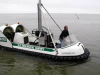 Hoverprobe |
Bratton, J.F.; Bohlke, J.K.; Manheim, F.T.; Krantz, D.E., 2004, Ground water beneath coastal bays of the Delmarva Peninsula-Ages and nutrients: Groundwater, vol. 42, issue 7, https://doi.org/10.1111/j.1745-6584.2004.tb02641.x.
Bratton, J.F., 2010, The three scales of submarine groundwater flow and discharge across passive continental margins: The Journal of Geology, v. 118 no. 5, doi: 10.1086/655114.
| Survey Equipment | Survey Info | Data Type(s) | Data Collected |
|---|---|---|---|
| Hoverprobe | --- | Geology | |
| Water sampler | --- | Chemistry | |
| Resistivity Profiler | --- | Resistivity | |
| Temperature and salinity | --- | CTD Temperature |
