Other ID: IB B-87-01-DL
Status: Completed
Organization(s): USGS, Woods Hole Coastal and Marine Science Center
Funding Program(s):
Principal Investigator(s): John Bratton
Affiliate Investigator(s): Frank Manheim - USGS, Reston
Information Specialist(s): John Bratton
Data Type(s): Sampling: Geology, Electro-Magnetic: Magnetics, Environmental Data: Conductivity, Sampling: Chemistry
Scientific Purpose/Goals: Collect core samples to: (1) verify results of previous resistivity surveys by targeting paired low-resistivity (brackish) and high-resistivity (fresh) sites, and (2) determine the influence of paleotopography on ground water flow by choosing nearshore and offshore targets in a known incised paleovalley imaged in previous seismic surveys.
Vehicle(s):
Start Port/Location:
End Port/Location:
Start Date: 2001-10-22
End Date: 2001-10-30
Equipment Used: Alpine Vibracorer, Downhole gamma and EM induction tools, data logger, Piezometer, Pore water sampling
Information to be Derived:
Summary of Activity and Data Gathered: Cores and gamma logs from four sites provided a vertical sequence of lithology to correlate with the seismic profiles and infer permeability structure. EM logs were run to measure pore fluid conductivities for comparison with the resistivity profiles. The gamma and EM logs were interpreted to guide in situ sampling of discrete ground water masses using a screened drivepoint for geochemistry and age dating. The combined results show a complex and dynamic system of ground water flow with appreciable control by stratigraphy. The flow of fresh ground water produces plumes 20 m thick and 400 to 600 m wide that may extend 1 km or more from shore beneath the estuary. The lateral boundaries of a fresh water plume may be abrupt and nearly vertical, or extend horizontally as a diffuse layer for hundreds of meters. The lower boundary of the plume shallows moving offshore and a mixing zone with brackish water develops. The ground water plumes studied follow incised valleys of tributary streams, but the dimensions of the plumes are much larger than the valleys. The fine-grained, low-permeability sediments filling the valleys appear to act as semiconfining layers that restrict infiltration of the overlying saline water of the estuary and permit flow of fresh water far offshore.
Staff: John Bratton
Affiliate Staff:
Frank Manheim - USGS-Reston; JK Bohlke - USGS-Reston; Dave Krantz - U. Toledo
and two students (Pam Haywood and Demola Soyinka); Peter Swarzenski - USGS-St. Petersburg
and USF intern (Morgan Crawford); Bob Frasier and Don Queen
USGS-Reston; Hugh Scott
MPI Drilling; Dan Phelan
USGS WRD-Baltimore
Notes: Results are contained in a set of three papers and a report as follows: Bratton, John F., Bohlke, J.K., Manheim, Frank T., Krantz, David E., 2004, Ground water beneath coastal bays of the Delmarva Peninsula: Ages and nutrients: Ground Water, vol. 42, no. 7, p. 1021-1034. Manheim, Frank T., David E. Krantz, John F. Bratton, 2004, Studying ground water under Delmarva coastal bays using electrical resistivity: Ground Water, vol. 42, no. 7, p. 1052-1068. Krantz, David E., Frank Manheim, John F. Bratton, Daniel J. Phelan, 2004, Hydrogeologic setting and ground water flow beneath a section of Indian River Bay, Delaware: Ground Water, vol. 42, no. 7, p. 1035-1051. Bohlke, John Karl, and David E. Krantz, Isotope Geochemistry and Chronology of Offshore Ground Water Beneath Indian River Bay, Delaware, Water-Resources Investigations Report 03-4192, http://pubs.usgs.gov/wri/wri034192/.
Project = Atlantic Ground-Water Systems - Delmarva Bays, Atlantic Ground-Water Systems - Delmarva Bays
Location:
Holts Landing State Park, south shore, Indian River Bay, Delaware, United States, North America, North Atlantic;
| Boundaries | |||
|---|---|---|---|
| North: 38.60833 | South: 38.58333 | West: -75.136 | East: -75.126 |
Platform(s):
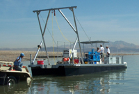 UNLV Coring Barge |
Bratton, J.F.; Bohlke, J.K.; Manheim, F.T.; Krantz, D.E., 2004, Ground water beneath coastal bays of the Delmarva Peninsula-Ages and nutrients: Groundwater, vol. 42, issue 7, https://doi.org/10.1111/j.1745-6584.2004.tb02641.x.
Bratton, J.F., 2010, The three scales of submarine groundwater flow and discharge across passive continental margins: The Journal of Geology, v. 118 no. 5, doi: 10.1086/655114.
Krantz, D.E., Manheim, Frank T., Bratton, John F., and Phelan, Daniel J., 2004, Hydrogeologic setting and ground water flow beneath a section of Indian River Bay, Delaware: Ground Water, v. 42 no. 7, doi: 10.1111/j.1745-6584.2004.tb02642.x.
Manheim, F.T., Krantz, David E., and Bratton, John F., 2004, Studying ground water under Delmarva coastal bays using electrical resistivity: Ground Water, v. 42 no. 7, doi: 10.1111/j.1745-6584.2004.tb02643.x.
| Survey Equipment | Survey Info | Data Type(s) | Data Collected |
|---|---|---|---|
| Alpine Vibracorer | --- | Geology | |
| Downhole gamma and EM induction tools, data logger | --- | Magnetics | |
| Piezometer | --- | Conductivity | |
| Pore water sampling | --- | Chemistry |
