Other ID: none
Status: Completed
Organization(s): USGS, Woods Hole Coastal and Marine Science Center
Funding Program(s):
Principal Investigator(s): David Foster
Affiliate Investigator(s): WHOI
Information Specialist(s): David Foster
Data Type(s): Location-Elevation: Navigation, Seismics: Boomer, Seismics: Sub Bottom Profiler
Scientific Purpose/Goals: Test and compare boomer seismic system with EdgeTech Chirp 512 system. Locate paleochannels between Woods Hole and Waquoit Bay.
Vehicle(s):
Start Port/Location: Woods Hole, MA
End Port/Location: Woods Hole, MA
Start Date: 2003-06-02
End Date: 2003-06-03
Equipment Used: GPS (wh), Boomer, Edgetech chirp subbottom profiler 512i
Information to be Derived:
Summary of Activity and Data Gathered: EdgeTech Chirp seismic data archived on CD-R.
Staff: David Foster, David Nichols
Affiliate Staff:
Stephen Swift
WHOI
PI; David Olmstead
WHOI
Captain
Notes:
Project = Field testing Edgetech 512i and 424 Chirp, Field testing Edgetech 512i and 424 Chirp
Location:
Vineyard Sound, Falmouth, Massachusetts, United States, North America, North Atlantic;
| Boundaries | |||
|---|---|---|---|
| North: 41.56667 | South: 41.5 | West: -70.6667 | East: -70.5 |
Platform(s):
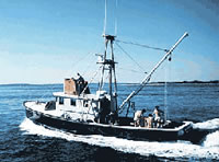
 Asterias |
| Survey Equipment | Survey Info | Data Type(s) | Data Collected |
|---|---|---|---|
| GPS (wh) | --- | Navigation | |
| Boomer | --- | Boomer | |
| Edgetech chirp subbottom profiler 512i | --- | Sub Bottom Profiler |