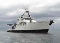
Other ID: P-1-03-MB
Status: Completed
Organization(s): USGS, Woods Hole Coastal and Marine Science Center
Funding Program(s):
Principal Investigator(s): Marinna Martini
Affiliate Investigator(s): U.S. Naval Postgraduate School
Information Specialist(s): Frances Lightsom
Data Type(s): Location-Elevation: Navigation, Environmental Data: CTD, Environmental Data: Temperature, Time Series: Mooring (physical oceanography)
Scientific Purpose/Goals: Recover partial moorings 705 and 706.
Vehicle(s):
Start Port/Location: Moss Landing, CA
End Port/Location: Moss Landing, CA
Start Date: 2003-11-25
End Date: 2003-11-26
Equipment Used: DGPS, Temperature and salinity, Pressure, Turbidity, Current
Information to be Derived:
Summary of Activity and Data Gathered: Moorings recovered: 2 (#705 and 706 deployed FA 02057 POINT SUR Dec. 5-7, 2002). Moorings 705 and 706 recovered on this trip, the bottom instrument package and release lost due to release failure, the rest recovered. Mooring #704 broke free about 10 days earlier and was recovered by Marla Stone of the Naval Postgraduate School (FA 03056 SHANA RAE Nov. 19, 2002). The wire failed above the bottom instrument package and release and thus those were lost on this mooring also.
Staff: Jonathan Borden, Marinna Martini, Richard Rendigs, Stephen Ruane
Affiliate Staff:
USGS-Menlo Park: Marlene Noble
Harold Williams
Jingping Xu
Joanne Ferreira; Naval Postgraduate School: Marla Stone
Notes: Original Center People field contained: At sea: Stephen Ruane, Marinna Martini, Jonathan Borden, Richard Rendigs.
Project = Monterey Canyon, Monterey Canyon
Location:
Monterey Bay Canyon Axis, California, United States, North America, North Pacific;
| Boundaries | |||
|---|---|---|---|
| North: 36.78033 | South: 26.71667 | West: -122.9632 | East: -122.01333 |
Platform(s):
 Point Sur |
| Survey Equipment | Survey Info | Data Type(s) | Data Collected |
|---|---|---|---|
| DGPS | --- | Navigation | |
| Temperature and salinity | --- | CTD Temperature | |
| Pressure | --- | Mooring (physical oceanography) | |
| Turbidity | --- | Mooring (physical oceanography) | |
| Current | --- | Mooring (physical oceanography) |