Other ID: none
Status: Completed
Organization(s): USGS, Woods Hole Coastal and Marine Science Center
Funding Program(s):
Principal Investigator(s): David Twichell
Affiliate Investigator(s): Linda Rowe, NOAA
Information Specialist(s): Brian Andrews
Data Type(s): Imagery: Photo, Location-Elevation: Navigation, Seismics: Sub Bottom Profiler, Sonar: Sidescan, Sonar: Interferometric
Scientific Purpose/Goals: Map the sea floor and shallow stratigraphy of Apalachicola Bay using sidescan sonar, bathymetry and high-resolution seismic to determine the controls on the distribution of oyster beds.
Vehicle(s):
Start Port/Location: Apalachicola, FL
End Port/Location: Apalachicola, FL
Start Date: 2005-03-17
End Date: 2005-04-14
Equipment Used: Real Time Kinematic GPS, Knudsen CHIRP Sub-bottom Profiler, Digital camera, SEA SWATHplus-M 234 kHz, Klein 595 100/500kHz sidescan sonar
Information to be Derived:
Summary of Activity and Data Gathered: This first year of a two-year program to map the floor of Apalachicola Bay focused on the eastern part of the Apalachicola Bay National Estuarine Research Reserve known as St. George Sound. Weather had a major impact on the amount of data collected during this field program. Because of the shallow depth of the bay (average depth 3 m), the sidescan sonar had to be towed close to the sea surface. When the wind exceeded approximately 15 kts the surface noise degraded the sidescan sonar imagery below an acceptable quality. The only areas not mapped were the crests of the oyster bars where water was less than 2 m deep, and a narrow band in the central part of the bay that could not be completed due to weather conditions. Sidescan sonar imagery, Submetrix bathymetry, and chirp sub-bottom profiles were collected simultaneously and were navigated using RTK DGPS. Tracklines were spaced 75-100 m apart and allowed complete sidescan sonar coverage, while the line spacing was such that, in these water depths, the interferometric bathymetry imaged 30-50% of the sea floor. Some parts of the floor of the bay were covered by muddy gas-charged sediment, and in these areas the sub-bottom penetration was minimal.
Staff: Brian Andrews, Emile Bergeron, William Danforth, Barry Irwin, David Nichols, Charles Worley
Affiliate Staff:
Data interpretation and ground truth operations: Linda Rowe
NOAA Coastal Services Center; Assist with operations and participate in ground truth studies: Director
Apalachicola Bay National Estuarine Reserve
Notes: Original Center People field contained: Boat operator: Barry Irwin; Technicians: Chuck Worley, Emile Bergeron; Data processors: William Danforth, Brian Andrews; Transport: Barry Irwin, Dave Nichols.
Project = Geologic/habitat mapping in Apalachicola Bay, FL, Geologic/habitat mapping in Apalachicola Bay, FL
Location:
St. George Sound, eastern Apalachicola Bay National Estuarine Research Reserve, Apalachicola Bay, Florida, United States, Gulf of Mexico, North America, North Atlantic;
| Boundaries | |||
|---|---|---|---|
| North: 29.86252999 | South: 29.52266183 | West: -84.7018 | East: -84.16485596 |
Platform(s):
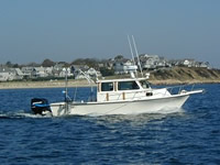
 Rafael |
Cross, V.A., Twichell, D.C., Foster, D.S., and O'Brien, T.F., 2012, Apalachicola Bay interpreted seismic horizons and updated IRIS chirp seismic-reflection data: U.S. Geological Survey Open-File Report 2012-1003, URL: https://doi.org/10.3133/ofr20121003.
Osterman, L.E., Twichell, David C., and Poore, Richard Z., 2009, Holocene evolution of Apalachicola Bay, Florida: Geo-Marine Letters, v. 29 no. 6, doi: 10.1007/s00367-009-0159-1.
Twichell, D., Edmiston, L., Andrews, B., Stevenson, W., Donoghue, J., Poore, R., and Osterman, L., 2010, Geologic controls on the recent evolution of oyster reefs in Apalachicola Bay and St. George Sound, Florida: Estuarine, Coastal and Shelf Science, v. 88 no. 3, pp. 385–394, doi: 10.1016/j.ecss.2010.04.019.
Twichell, D.C., Andrews, B.D., Edmiston, H.L., and Stevenson, W.R., 2007, Geophysical mapping of oyster habitats in a shallow estuary; Apalachicola Bay, Florida: U.S. Geological Survey Open-File Report 2006-1381, https://doi.org/10.3133/ofr20061381.
Twichell, D.C., Pendleton, E.A., Poore, R.Z., Osterman, L.E., and Kelso, K.W., 2009, Vibracore, radiocarbon, microfossil, and grain-size data from Apalachicola Bay, Florida: U.S. Geological Survey Open-File Report 2009-1031, URL: https://doi.org/10.3133/ofr20091031.
| Survey Equipment | Survey Info | Data Type(s) | Data Collected |
|---|---|---|---|
| Real Time Kinematic GPS | --- | Navigation | |
| Knudsen CHIRP Sub-bottom Profiler | --- | Sub Bottom Profiler | 2005-001-FA-SE-001 (DVD ROM disk of SUBMETRIX) |
| Digital camera | --- | Photo | 2005-001-FA-PH-001 (Deck photos of field activity operations) |
| SEA SWATHplus-M 234 kHz | --- | Interferometric | |
| Klein 595 100/500kHz sidescan sonar | --- | Sidescan | 2005-001-FA-SO-001 (DVD ROM disk of KLEIN) |