Other ID: NURC/UNCW 2005-07B
Status: Completed
Organization(s): USGS, Woods Hole Coastal and Marine Science Center
Funding Program(s):
Principal Investigator(s): Kathryn Scanlon Catanach
Affiliate Investigator(s): Christopher Koenig, Chief Scientist, Florida State University
Information Specialist(s): Julia Knisel
Data Type(s): Imagery: Photo, Imagery: Video, Sampling: Biology, Sampling: Chemistry, Sampling: Geology, Location-Elevation: Navigation
Scientific Purpose/Goals: Collect sediment and rock samples from shelf-edge paleoshorelines and video grouper spawning habitat using ROV and mixed-gas SCUBA divers.
Vehicle(s):
Start Port/Location: St. Petersburg, FL
End Port/Location: St. Petersburg, FL
Start Date: 2005-03-21
End Date: 2005-03-28
Equipment Used: ROV, SCUBA, GPS (wh), Digital camera
Information to be Derived:
Summary of Activity and Data Gathered: The ROV was deployed at 19 sites both within the Madison Swanson Fishery Reserve and at unprotected areas outside the reserve. Video data and still photographs were collected at each site. At 4 sites Technical SCUBA divers, using mixed gas, were sent to the sea floor to collect rock samples with chisels and sledges. A total of 22 rock samples (most several inches to a foot in diameter) were collected. They will be analyzed for mineralogic composition and if possible dated and environment of deposition determined. The pre-cruise plan had included sediment and rock sampling in the Steamboat Lumps Fishery Reserve, but those goals were not achieved due to time lost to weather and equipment problems (ROV cable was caught in ship's screw and damaged, requiring retermination). Video data will be used by FSU collaborators to assess health of grouper spawning populations. Water samples were taken from inside a solution hole at one site and tested for salinity, which was 37 - 37.5 ppt, the same as the ambient water salinity measured about 10 feet above the sea floor. No water samples were saved. No sediment samples were collected.
Staff: Kathryn Scanlon Catanach, Julia Knisel
Affiliate Staff:
Christopher Koenig
FSU
chief scientist; Felicia Coleman
FSU
co-chief scientist in absentia; Lance Horn
NOAA-NURP/UNCW
ROV Operations and Tech. Diver; Glenn Taylor
NOAA-NURP/UNCW
ROV Operations and Tech. Diver; Jay Styron
NOAA-NURP/UNCW
Tech. Dive Master; Doug Kesling
NOAA-NURP/UNCW
Tech. Diver
Notes: All SCUBA diving operations were under direction of, and carried out by, NOAA personnel. Original Center People field contained: K. Scanlon, co-chief scientist; J. Knisel, GIS and data archive.
Project = Shelf-edge Habitats, NE Gulf of Mexico, Shelf-edge Habitats, NE Gulf of Mexico
Location:
Madison-Swanson Fishery Reserve, Florida, west Florida Shelf, United States, Gulf of Mexico, North America, North Atlantic;
| Boundaries | |||
|---|---|---|---|
| North: 29.5 | South: 28.5 | West: -86.5 | East: -85 |
Platform(s):
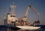 Liberty Star |
Coleman, F.C., Koenig, Christopher C., Scanlon, Kathryn M., Heppell, Scott, Heppell, Selina, and Miller, Margaret W., 2010, Benthic habitat modification through excavation by red grouper, Epinephelus morio, in the northeastern Gulf of Mexico: The Open Fish Science Journal, v. 3, doi: 10.2174/1874401X01003010001.
Scanlon, K.M., Waller, R.G., Sirotek, A.R., Knisel, J.M., O'Malley, J.J., and Alesandrini, S., 2010, USGS cold-water coral geographic database-Gulf of Mexico and western North Atlantic Ocean, version 1.0: U.S. Geological Survey Open-File Report 2008-1351, https://doi.org/10.3133/ofr20081351.
| Survey Equipment | Survey Info | Data Type(s) | Data Collected |
|---|---|---|---|
| ROV | --- | Photo Video Biology Geology | 2005-002-FA-SC-001 (grab samples) 2005-002-FA-VD-001 (DVD ROM disk of MADISON ROV DIVE 1, MADISON ROV DIVE 2, MADISON ROV DIVE 3,4, MADISON ROV DIVE 5,6, MADISON ROV DIVE 7A, MADISON ROV DIVE 7B, MADISON ROV DIVE 8,9,10, MADISON ROV DIVE 11,12, MADISON ROV DIVE 12B, MADISON ROV DIVE 13, MADISON ROV DIVE 14A, MADISON ROV DIVE 14B,15,16, MADISON ROV DIVE 17,18,19, ) |
| SCUBA | --- | Biology Chemistry Geology | |
| GPS (wh) | --- | Navigation | 2005-002-FA-LN-001 (Area maps and ship's track.) |
| Digital camera | --- | Photo |
