Other ID: none
Status: Completed
Organization(s): USGS, Woods Hole Coastal and Marine Science Center
Funding Program(s):
Principal Investigator(s): Walter Barnhardt
Affiliate Investigator(s): Joe Kelley, University of Maine
Information Specialist(s): Brian Andrews
Data Type(s): Location-Elevation: Navigation, Seismics: Sub Bottom Profiler, Sonar: Sidescan, Sonar: Sound Velocity, Sonar: Interferometric
Scientific Purpose/Goals: Sea floor mapping of pockmark field at mouth of Penobscot River.
Vehicle(s):
Start Port/Location: Belfast, ME
End Port/Location: Belfast, ME
Start Date: 2006-09-11
End Date: 2006-09-18
Equipment Used: Real Time Kinematic GPS, EdgeTech 424 chirp sub-bottom profiler, SEA SWATHplus-M 234 kHz, Klein 3000, Sensor - SVP
Information to be Derived:
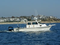
Summary of Activity and Data Gathered: The survey took place from 11-18 September on board the R/V Rafael. We collected swath bathymetry, sidescan sonar backscatter, and sub-bottom profiles over an area of approximately 25 km2. The survey focused on the mouth of the Penobscot River where it enters upper Penobscot Bay (also known as Belfast Bay). This area is the primary depositional site for sediment carried by the river, and would probably experience significant impacts if/when the proposed dam removals occur in upstream areas. With these data as a pre-removal baseline, we will be able to quantify any changes in bottom morphology and substrate conditions that might result from releasing sediment from upstream impoundments. These new data will be compared to a bathymetric survey collected in 1999 by NOAA that covers part of the same area. Where the data overlap, we will be able to determine what (if any) changes have occurred over the last 7 years and make conclusions about the rates and patterns of sediment accumulation at the mouth of the river.
Staff: Brian Andrews, Walter Barnhardt, Emile Bergeron, William Danforth, Barry Irwin
Affiliate Staff:
Joe Kelley and Laura Brothers
University of Maine
Notes: Original Center People field contained: Barry Irwin (boat captain); William Danforth (tech); Emile Bergeron (tech); Brian Andrews (data processing); Walter Barnhardt (PI).
Project = Belfast Bay Pockmarks, Belfast Bay Pockmarks
Location:
Penobscot River, Belfast Bay, Penobscot Bay, Maine, United States, North Atlantic;
| Boundaries | |||
|---|---|---|---|
| North: 44.5 | South: 44.33333 | West: -69 | East: -68.75 |
Platform(s):
 Rafael |
Andrews, B.D., Brothers, L.L., Barnhardt, W.A., 2010, Automated feature extraction and spatial organization of seafloor pockmarks, Belfast Bay, Maine, USA: Geomorphology, v. 124 no. 1-2, pp. 55–64, doi: 10.1016/j.geomorph.2010.08.009.
Andrews, B.D., Danforth, W. W., Brothers, L.L., Barnhardt, W. A., 2020, High-resolution geophysical data collected in the Belfast Bay, Maine pockmark field in 2006, 2008, and 2009 by the U.S. Geological Survey: U.S. Geological Survey data release, https://doi.org/10.5066/P90QQCOR.
Ludine, M.A., Brothers, L.L., Trembanis, A.C., 2022, Deep Learning for Pockmark Detection: Implications for quantitative seafloor characterization: Geomorphology, , doi: 10.1016/j.geomorph.2022.108524.
| Survey Equipment | Survey Info | Data Type(s) | Data Collected |
|---|---|---|---|
| Real Time Kinematic GPS | --- | Navigation | |
| EdgeTech 424 chirp sub-bottom profiler | --- | Sub Bottom Profiler | |
| SEA SWATHplus-M 234 kHz | --- | Interferometric | |
| Klein 3000 | --- | Sidescan | |
| Sensor - SVP | --- | Sound Velocity |