Other ID: none
Status: Completed
Organization(s): USGS, Woods Hole Coastal and Marine Science Center
Funding Program(s):
Principal Investigator(s): Michael Bothner
Affiliate Investigator(s):
Information Specialist(s): Michael Casso
Data Type(s): Imagery: Photo, Sampling: Biology, Sampling: Geology
Scientific Purpose/Goals: Collect yellow perch and small mouth bass to assess the level of mercury contamination.
Vehicle(s):
Start Port/Location: WHSC, Woods Hole, MA
End Port/Location: WHSC, Woods Hole, MA
Start Date: 2007-10-30
End Date: 2007-10-30
Equipment Used: Digital camera, Dip Nets
Information to be Derived: Mercury concentrations in yellow perch and small mouth bass;
Summary of Activity and Data Gathered: The following fish were collected with rod and reel: 1 small mouth bass, 4 yellow perch, 2 catfish.
Staff: Dann Blackwood, Michael Bothner, Michael Casso
Affiliate Staff:
Notes: Project = Coastal Geologic Processes and Long-Term Environmental Change, Coastal Geologic Processes and Long-Term Environmental Change
Location:
Deep Pond, Falmouth, Massachusetts, United States, North America;
| Boundaries | |||
|---|---|---|---|
| North: 41.56667 | South: 41.56167 | West: -70.6417 | East: -70.63 |
Platform(s):
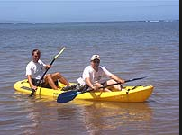 Kayak |
| Survey Equipment | Survey Info | Data Type(s) | Data Collected |
|---|---|---|---|
| Digital camera | --- | Photo | 2007-041-FA-PH-001 (30 shore photos including operations and catch.) |
| Dip Nets | --- | Biology | 2007-041-FA-SC-001 (Fish catch: 1 small mouth bass, 4 yellow perch, 2 catfish, 1 frog, 1 tadpole.) |
