Other ID: none
Status: Completed
Organization(s): USGS, Woods Hole Coastal and Marine Science Center
Funding Program(s):
Principal Investigator(s): Jane Denny
Affiliate Investigator(s):
Information Specialist(s): William Danforth, Jane Denny
Data Type(s): Sonar: Interferometric, Sonar: Multibeam, Location-Elevation: Navigation
Scientific Purpose/Goals: Collect bathymetric data within Muskeget Channel and surrounding area.
Vehicle(s):
Start Port/Location:
End Port/Location:
Start Date: 2010-10-04
End Date: 2010-10-15
Equipment Used: SEA SWATHplus-M 234 kHz, Real Time Kinematic GPS
Information to be Derived:
Summary of Activity and Data Gathered: Approximately 175 km of swath bathymetric data were collected within Muskeget Channel and adjacent areas to map the topography.
Staff: Wayne Baldwin, William Danforth, Barry Irwin
Affiliate Staff:
Notes: 3 days of surveying are needed. A two-week period is reserved in case of weather. 3 days will also be needed at the end of October. Due to windy conditions, cruise dates were extended into the first 2 weeks of October.
Location:
Muskeget Channel, Nantucket Sound, Massachusetts, United States, North America, North Atlantic;
| Boundaries | |||
|---|---|---|---|
| North: 41.36959 | South: 41.30567 | West: -70.432 | East: -70.32349 |
Platform(s):
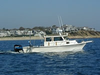
 Rafael |
Pendleton, E.A., Denny, J.F., Danforth, W.W., Baldwin, W.E., and Irwin, B.J., 2014, High-resolution swath interferometric data collected within Muskeget Channel, Massachusetts: U.S. Geological Survey Open-File Report 2012–1258, https://doi.org/10.3133/ofr20121258.
| Survey Equipment | Survey Info | Data Type(s) | Data Collected |
|---|---|---|---|
| SEA SWATHplus-M 234 kHz | --- | Interferometric | |
| Real Time Kinematic GPS | --- | Navigation |