Other ID: none
Status: Completed
Organization(s): USGS, Woods Hole Coastal and Marine Science Center
Funding Program(s):
Principal Investigator(s): David Foster, William Schwab
Affiliate Investigator(s):
Information Specialist(s): David Foster
Data Type(s): Seismics: Boomer, Seismics: Multichannel, Location-Elevation: Navigation
Scientific Purpose/Goals: Supplement existing Chirp subbottom profiles in Buzzards Bay and Vineyard Sound with deeper penetration Boomer profiling system. These data will contribute to a more complete geologic framework for the Mass CZM mapping program.
Vehicle(s):
Start Port/Location: Woods Hole, MA
End Port/Location: Woods Hole, MA
Start Date: 2011-01-06
End Date: 2011-01-06
Equipment Used: Boomer, Multichannel seismics, DGPS
Information to be Derived: Morphology;Seismic stratigraphy
Summary of Activity and Data Gathered: 20.8 km of 8-channel boomer seismic reflection data were collected in Vineyard Sound. Objectives for Buzzards bay were not met due to winter weather conditions.
Staff: Wayne Baldwin, Emile Bergeron, Barry Irwin, Thomas O'Brien, Charles Worley
Affiliate Staff:
Notes:
Project = MCZM/B. Bay & Vineyard Sound, MCZM/B. Bay & Vineyard Sound
Location:
Vineyard Sound, Cape Cod, Marthas Vineyard, United States, North America, North Atlantic;
| Boundaries | |||
|---|---|---|---|
| North: 41.4943 | South: 41.39256 | West: -70.7992 | East: -70.59933 |
Platform(s):
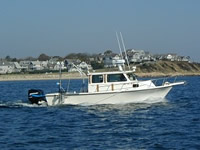
 Rafael |
Pendleton, E.A., Andrews, B.D., Danforth, W.W., and Foster, D.S., 2014, High-resolution geophysical data collected aboard the U.S. Geological Survey research vessel Rafael to supplement existing datasets from Buzzards Bay and Vineyard Sound, Massachusetts: U.S. Geological Survey Open-File Report 2013–1020, 6 p., https://doi.org/10.3133/ofr20131020.
| Survey Equipment | Survey Info | Data Type(s) | Data Collected |
|---|---|---|---|
| Boomer | --- | Boomer | |
| Multichannel seismics | --- | Multichannel | |
| DGPS | --- | Navigation |