Other ID: none
Status: Completed
Organization(s): USGS, Woods Hole Coastal and Marine Science Center
Funding Program(s): Sea and Lake Floor Mapping (LQ000FL)
Principal Investigator(s): Katherine McMullen, Lawrence Poppe
Affiliate Investigator(s):
Information Specialist(s): Katherine McMullen
Data Type(s): Imagery: Photo, Imagery: Video, Location-Elevation: Navigation, Sampling: Geology, Visual Identification: Ground Truthing
Scientific Purpose/Goals: Ground-truth 2 NOAA multibeam surveys with bottom sampling and photography
Vehicle(s):
Start Port/Location: Middletown, RI
End Port/Location: Middletown, RI
Start Date: 2014-09-15
End Date: 2014-09-17
Equipment Used: Other, DGPS, SeaBOSS
Information to be Derived: Sedimentary processes and environments
Summary of Activity and Data Gathered: 205 photographs, 2 DVDs of bottom video, and 32 sediment samples for grain-size analysis were obtained during the survey.
Staff: Dann Blackwood, Barry Irwin, Katherine McMullen, Lawrence Poppe
Affiliate Staff:
Notes: 42 stations were occupied. Samples and(or) visual descriptions and bottom photography (still photographs and video) were acquired at each station. Two log books and 2 DVDs of bottom video were produced during this field activity.
Location:
Narragansett Bay and Rhode Island Sound, Rhode Island, United States, Atlantic Ocean
| Boundaries | |||
|---|---|---|---|
| North: 41.57847058 | South: 41.4362275 | West: -71.4166 | East: -71.29137573 |
Platform(s):
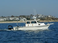
 Rafael |
McMullen, K.Y., Poppe, L.J., Blackwood, D.S., Nardi, M.J., and Andring, M.A., 2015, Sea-floor morphology and sedimentary environments in southern Narragansett Bay, Rhode Island: U.S. Geological Survey Open-File Report 2015–1149, 1 DVD-ROM, http://dx.doi.org/10.3133/ofr20151149.
| Survey Equipment | Survey Info | Data Type(s) | Data Collected |
|---|---|---|---|
| Other | --- | --- | --- |
| DGPS | DGPS recorded by CSI LGBX Pro Differential Global Positioning System (DGPS) with HYPACK software | Navigation | |
| SeaBOSS | Mini SeaBOSS collected sediment samples, bottom video, and still photographs | Surveys (biological) Experiments (biological) Species ID Photo Video Geology Biology |