AKA: none
Other ID: none
Status: Completed
Organization(s): USGS, Pacific Coastal and Marine Science Center, USGS, Woods Hole Coastal and Marine Science Center
Funding Program(s): Coastal and marine earthquake, tsunami, and landslide active margin field studies (ZP00EQV)
Principal Investigator(s): Daniel Brothers
Affiliate Investigator(s):
Information Specialist(s): James Conrad, Ray Sliter
Data Type(s): Location-Elevation: Navigation, Seismics: Multichannel, Seismics: Sparker, Seismics: Sub Bottom Profiler
Scientific Purpose/Goals: low-energy, high-resolution multichannel seismic reflection survey offshore southern California to assess the earthquake and submarine landslide hazards
Vehicle(s): None
Start Port/Location: San Diego, California
End Port/Location: San Diego, California
Start Date: 2014-11-12
End Date: 2014-11-25
Equipment Used: navigation, Other, Sparker, multichannel, 512 chirp
Information to be Derived: seismic stratigraphy, fault/basin structure, tectonic deformation
Summary of Activity and Data Gathered: raw data Sproul_2014 on FAD
Staff: Jackson Currie, Robert Wyland
Affiliate Staff:
Notes: Cruise will be aboard the R/V Robert Gordon Sproul using 48-ch MCS streamer, SC single channel 500 joule acoustic sparker from Woods Hole and and 512 chirp from PCMG.
Chuck Worley of WHSC will also participating
Location:
Southern California Borderlands
| Boundaries | |||
|---|---|---|---|
| North: 34.22542902 | South: 32.75509185 | West: -120.443 | East: -117.26803153 |
Platform(s):
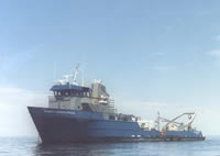 Robert Gordon Sproul |
Balster-Gee, A.F., Kluesner, J.W., Brothers, D.S., Conrad, J.E., and Sliter, R.W., 2017, Minisparker and chirp seismic-reflection data of field activity 2014-645-FA; offshore Santa Barbara, southern California from 2014-11-12 to 2014-11-25 (ver. 2.0, March 2020): U.S. Geological Survey data release, https://doi.org/10.5066/F7CV4FW6.
Conrad, J.E., Prouty, N.G., Walton, M.A.L., Kluesner, J.W., Maier, K.L., McGann, M., Brothers, D.S., Roland, E.C., and Dartnell, P., 2018, Seafloor fluid seeps on Kimki Ridge, offshore southern California: Links to active strike-slip faulting: Deep Sea Research Part II: Topical Studies in Oceanography, Special Issue 'Results of Telepresence-Enabled Oceanographic Exploration', v. 150, pp. 82–91, URL: https://doi.org/10.1016/j.dsr2.2017.11.001.
Kluesner, J., Brothers, D., Hart, P., Miller, N., and Hatcher, G., 2019, Practical approaches to maximizing the resolution of sparker seismic reflection data: Marine Geophysical Research, v. 40 no. 3, pp. 279–301, URL: https://doi.org/10.1007/s11001-018-9367-2.
Walton, M.A.L., Brothers, D.S., Conrad, J.E., Maier, K.L., Roland, E.C., Kluesner, J.W., and Dartnell, P., 2020, Morphology, structure, and kinematics of the San Clemente and Catalina faults based on high-resolution marine geophysical data, southern California Inner Continental Borderland (USA): Geosphere, , URL: https://doi.org/10.1130/GES02187.1.
| Survey Equipment | Survey Info | Data Type(s) | Data Collected |
|---|---|---|---|
| navigation | --- | Navigation | |
| Other | --- | --- | --- |
| Sparker | --- | Sparker | |
| multichannel | --- | Multichannel | Multichannel sparker and minisparker seismic-reflection data of USGS field activity 2014-645-FA collected in the outer Santa Barbara Channel, California, between 2014-11-12 to 2014-11-25 (ver. 2.0, March 2020) (This data release contains 35 multichannel sparker and 24 multichannel minisparker seismic reflection (MCS) profiles that were collected in November of 2014 from the Catalina and Santa Cruz Basins offshore southern California by the U.S. Geological Survey Pacific and Coastal Marine Science Center. Data were collected aboard the University of California’s R/V Robert Gordon Sproul on USGS cruise 2014-645-FA. MCS profiles were collected to assess earthquake and submarine landslide hazards offshore southern California.) |
| 512 chirp | --- | Sub Bottom Profiler | Chirp seismic-reflection data of USGS field activity 2014-645-FA collected in the outer Santa Barbara Channel, California, between 2014-11-12 to 2014-11-25 (ver. 2.0, March 2020) (This data release contains 43 chirp sub-bottom profiles that were collected in November of 2014 from the Catalina and Santa Cruz Basins offshore southern California by the U.S. Geological Survey Pacific and Coastal Marine Science Center. Data were collected aboard the University of California’s R/V Robert Gordon Sproul on USGS cruise 2014-645-FA. Chirp profiles were collected to assess earthquake and submarine landslide hazards offshore southern California.) |
