Other ID: none
Status: Completed
Organization(s): USGS, Woods Hole Coastal and Marine Science Center
Funding Program(s): USGS GAS HYDRATES (LQ000FP)
Principal Investigator(s): Carolyn Ruppel
Affiliate Investigator(s): Colwell (OSU), Krause (Geomar)
Information Specialist(s): Carolyn Ruppel
Data Type(s): Environmental Data: CTD, Imagery: Video, Location-Elevation: Navigation, Sampling: Biology, Sampling: Chemistry, Sampling: Geology, Seismics: Sub Bottom Profiler, Sonar: Single Beam, Sonar: Water column reflectivity
Scientific Purpose/Goals: Upper slope gas hydrate dynamics on disparate part of the margin (with and without seeps; with and without long erosional history)
Vehicle(s):
Start Port/Location: Lewes, DE
End Port/Location: Lewes, DE
Start Date: 2015-09-07
End Date: 2015-09-22
Equipment Used: Piston corer, SIMRAD EK60, DGPS, CTD 19+ with OBS, PAR, DO, Chl, Video camera - deep sea, HYPACK, Push corer (wh), Sample containers, Cavity Ring-Down Spectroscopy (CRDS), Niskin bottle, Pore water sampling, Rhizons, Other, EdgeTech 516 CHIRP Sub-bottom Profiler
Information to be Derived: heat flow data; water column CH4 concentrations; subbottom imaging; pore water organic & inorganic chemistry, gas composition and carbon isotopes
Summary of Activity and Data Gathered: Piston cores, multicores, real-time video on multicores, EK60 data, Chirp 424 data, CTDs
Staff: Lee-Gray Boze, Brian Buczkowski, Michael Casso, William Danforth, Eric Moore, John Pohlman, Carolyn Ruppel
Affiliate Staff:
Notes: > PISTON CORING CRUISE (using PCMSC gear)
> Heat flow instrumentation will be provided by NSF facility at UCSC
> Edgetech 512 needed
> CTD will be provided and staffed by U Delaware
Location:
Atlantic margin between Alvin Canyon and Cape Hatteras
| Boundaries | |||
|---|---|---|---|
| North: 41.5085773 | South: 34.65551972 | West: -74.5313 | East: -69.53125 |
Platform(s):
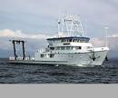 Hugh R. Sharp |
| Survey Equipment | Survey Info | Data Type(s) | Data Collected |
|---|---|---|---|
| Piston corer | PCMSC piston coring system | Geology | |
| SIMRAD EK60 | --- | Surveys (biological) Surveys (geochemical) Multibeam Water column reflectivity | |
| DGPS | USGS used its own portable GPS unit for navigation and ship also supplied a separate navigation stream. | Navigation | |
| CTD 19+ with OBS, PAR, DO, Chl | --- | CTD | |
| Video camera - deep sea | --- | Video | |
| HYPACK | --- | Navigation | |
| Push corer (wh) | --- | Biology Geology | |
| Sample containers | --- | Biology Geology | |
| Cavity Ring-Down Spectroscopy (CRDS) | --- | CO2 Methane Experiments (geochemical) Surveys (geochemical) Chemistry | DSIM_EnvironmentalDataMethodComparision_2021 (Comparison of methane concentration and stable carbon isotope data for natural samples analyzed by discrete sample introduction module - cavity ring down spectroscopy (DSIM-CRDS) and traditional methods) |
| Niskin bottle | --- | Chemistry | |
| Pore water sampling | --- | Chemistry | |
| Rhizons | --- | Chemistry | |
| Other | --- | --- | --- |
| EdgeTech 516 CHIRP Sub-bottom Profiler | --- | Sub Bottom Profiler |
