Other ID: none
Status: Completed
Organization(s): Other, USGS, Woods Hole Coastal and Marine Science Center
Funding Program(s): USGS GAS HYDRATES (LQ000FP)
Principal Investigator(s): John Pohlman
Affiliate Investigator(s):
Information Specialist(s): Michael Casso, John Pohlman
Data Type(s): Environmental Data: Chlorophyll, Environmental Data: CO2, Environmental Data: Conductivity, Environmental Data: CTD, Environmental Data: Depth, Environmental Data: Dissolved Oxygen, Environmental Data: Fluorescence, Environmental Data: Meteorology, Environmental Data: Methane, Environmental Data: pH, Environmental Data: Temperature, Location-Elevation: Navigation, Sampling: Chemistry, Time Series: Geochemical Monitoring
Scientific Purpose/Goals: To gather time series methane flux data in a field of known methane seeps on the seafloor.
Vehicle(s):
Start Port/Location: Tromso, Norway
End Port/Location: Longyearbyen, Norway
Start Date: 2015-06-28
End Date: 2015-07-06
Equipment Used: Other, Niskin bottle, HYPACK, Cavity Ring-Down Spectroscopy (CRDS), YSI multiparameter sonde, Temperature and salinity
Information to be Derived: Methane and CO2 concentrations in air and water.
Summary of Activity and Data Gathered: Methane and CO2 concentrations in air and water were collected. Data have not been processed.
Staff: John Pohlman
Affiliate Staff:
Notes: The USGS-Gas Analysis System (USGS-GAS) was used to measure CO2 and CH4.
Location:
Area west of Prins Karls Forland (island on the west side of Svalbard, Norway).
| Boundaries | |||
|---|---|---|---|
| North: 79.00496216 | South: 77.77125618 | West: 7.7124 | East: 12.42675781 |
Platform(s):
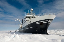
 Helmer Hanssen |
| Survey Equipment | Survey Info | Data Type(s) | Data Collected |
|---|---|---|---|
| Other | --- | --- | --- |
| Niskin bottle | Water samples collected for methane water column concentrations. | Chemistry | |
| HYPACK | Data aquisition software compiled data from numerous devices (e.g., CRDSs, YSI and airmars) | Navigation | |
| Cavity Ring-Down Spectroscopy (CRDS) | Analytical device for measuring CO2 and CH4 concentrations and carbon isotopes | CO2 Methane Experiments (geochemical) Surveys (geochemical) Chemistry | |
| YSI multiparameter sonde | Sonde data captured by HYPAK software | Conductivity Dissolved Oxygen ORP pH Temperature | |
| Temperature and salinity | Temp and salinity data collected by YSI sonde and ship CTD | CTD Temperature |