Other ID: none
Status: Completed
Organization(s): USGS, Woods Hole Coastal and Marine Science Center
Funding Program(s): Remote Sensing Coastal Change (ZP00GJA)
Principal Investigator(s): Christopher Sherwood
Affiliate Investigator(s):
Information Specialist(s): Seth Ackerman
Data Type(s): Sonar: Interferometric, Location-Elevation: Navigation, Seismics: Sub Bottom Profiler, Sonar: Sound Velocity
Scientific Purpose/Goals: Bathymetric, backscatter and sub-bottom mapping offshore of Town Neck Beach (
Vehicle(s):
Start Port/Location: Sandwich, MA
End Port/Location: Sandwich, MA
Start Date: 2016-05-16
End Date: 2016-05-27
Equipment Used: SEA SWATHplus-M 234 kHz, DGPS, Other, Knudsen CHIRP Sub-bottom Profiler, Sensor - MVP30 (Odim)
Information to be Derived: bathymetry, backscatter, sub-bottom data, samples
Summary of Activity and Data Gathered: Bathymetric, backscatter and sub-bottom data acquired
Staff: Barry Irwin
Affiliate Staff:
Notes: Full Staffing TBD
Location:
Town Neck Beach, Sandwich
| Boundaries | |||
|---|---|---|---|
| North: 41.78897693 | South: 41.75799552 | West: -70.50544739 | East: -70.45463562 |
Platform(s):
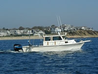
 Rafael |
Ackerman S.D., Foster D.S., Danforth W.W., and Huntley, E.C., 2019, High-resolution geophysical and sampling data collected off Town Neck Beach in Sandwich, Massachusetts, 2016: U.S. Geological Survey data release, https://doi.org/10.5066/P9HZHXXV.
Sherwood, C.R., Montgomery, E.T., Suttles, S.E. and Brosnahan, S.M., 2016, Oceanographic, Atmospheric and Water-Quality Measurements Sandwich Town Neck Beach, Massachusetts, 2016, https://doi.org/10.5066/F7N58JHM.
| Survey Equipment | Survey Info | Data Type(s) | Data Collected |
|---|---|---|---|
| SEA SWATHplus-M 234 kHz | --- | Interferometric | 2016-017-FA_Backscatter (Backscatter imagery collected in 2016 by the U.S. Geological Survey off Town Neck Beach Sandwich, Massachusetts during field activity 2016-017-FA (GeoTIFF image)) 2016-017-FA_Bathymetry2m_NAVD88 (2-meter bathymetric data collected in 2016 by the U.S. Geological Survey off Town Neck Beach Sandwich, Massachusetts during field activity 2016-017-FA (bathymetry GeoTIFF)) 2016-017-FA_SWATHplusTracklines (Survey lines along which swath sonar (bathymetric and backscatter) data were collected in 2016 by the U.S. Geological Survey off Town Neck Beach Sandwich, Massachusetts during field activity 2016-017-FA) |
| DGPS | --- | Navigation | |
| Other | --- | --- | --- |
| Knudsen CHIRP Sub-bottom Profiler | --- | Sub Bottom Profiler | 2016-017-FA_SeismicTracklines (Survey lines along which seismic reflection data were collected in 2016 by the U.S. Geological Survey off Town Neck Beach Sandwich, Massachusetts during field activity 2016-017-FA) 2016-017-FA_SeismicImages (PNG images of each chirp seismic profile collected in 2016 by the U.S. Geological Survey off Town Neck Beach Sandwich, Massachusetts during field activity 2016-017-FA) 2016-017-FA_SeismicShot500 (Shotpoint navigation at a 500-shot interval for chirp seismic-reflection data collected in 2016 by the U.S. Geological Survey off Town Neck Beach Sandwich, Massachusetts during field activity 2016-017-FA) |
| Sensor - MVP30 (Odim) | --- | Sound Velocity |