AKA: none
Other ID: none
Status: Completed
Organization(s): USGS, Pacific Coastal and Marine Science Center
Funding Program(s): Coastal Habitats in Puget Sound (ZP00AZZ)
Principal Investigator(s): Guy Gelfenbaum, Jonathan Warrick
Affiliate Investigator(s):
Information Specialist(s): Andrew Stevens
Data Type(s): Location-Elevation: Navigation, Location-Elevation: Transects, Sampling: Geology, Sonar: Single Beam
Scientific Purpose/Goals: Collect nearshore bathymetry, beach topography, and grain size information on the Elwha River delta
Vehicle(s): MarFac; Chevy Suburban - gray; 7 pass; G62-2874L
Start Port/Location: Port Angeles, WA
End Port/Location: Port Angeles, WA
Start Date: 2016-07-17
End Date: 2016-07-20
Equipment Used: Trimble R7 GPS (AS), Trimble R7 GPS receiver 9, Waverunners, Ponar grab sampler, Trimble R7 GPS receiver
Information to be Derived: Nearshore Bathymetry, Beach Topography, Surface Grainsize
Summary of Activity and Data Gathered: grainsize analysis submitted 11/10/2016 aerial_photos, bathy, benchmarks, field_notes, grainsize, grid, kayak, matlab, photos, planning, svp, topo and readme folders submitted 8/24/2016
Staff: Timothy Elfers, Guy Gelfenbaum, Andrew Stevens, Jonathan Warrick
Affiliate Staff:
Notes: Entries for this field activity are based on entries from Field Activity 2014-649-FA
Entries for this field activity are based on entries from Field Activity 2015-605-FA
Entries for this field activity are based on entries from Field Activity 2015-648-FA
Entries for this field activity are based on entries from Field Activity 2016-608-FA
Location:
Puget Sound
| Boundaries | |||
|---|---|---|---|
| North: 48.17624572 | South: 48.10493829 | West: -123.633 | East: -123.38360665 |
Platform(s):
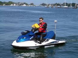
 Waverunner 1 (SC) |  Waverunner 2 (SC) |
| Survey Equipment | Survey Info | Data Type(s) | Data Collected |
|---|---|---|---|
| Trimble R7 GPS (AS) | --- | Benchmarks Navigation Profiles Transects | |
| Trimble R7 GPS receiver 9 | --- | Benchmarks LIDAR Navigation Profiles Transects | |
| Waverunners | --- | Navigation Single Beam | bathymetry data collected from kayak (published in ScienceBase; U.S. Geological Survey data release, doi: 10.5066/F7GQ6VXX) bathymetry data collected from personal watercraft (This part of the data release presents bathymetry data from the Elwha River delta collected in July 2016 using two personal watercraft (PWCs). The PWCs were equipped with single beam echosounders and survey-grade global navigation satellite system (GNSS) receivers.) |
| Ponar grab sampler | --- | Biology Chemistry Geology | grainsize data (published in ScienceBase; U.S. Geological Survey data release, doi: 10.5066/F7GQ6VXX) |
| Trimble R7 GPS receiver | --- | Benchmarks LIDAR Navigation Profiles Transects | Digital elevation models (DEMs) of the Elwha River delta, Washington, July 2016 (This part of the data release presents a digital elevation model (DEM) derived from bathymetry and topography data of the Elwha River delta collected in July 2016. Two dams on the Elwha River, Washington State, USA trapped over 20 million m3 of sediment, reducing downstream sediment fluxes and contributing to erosion of the river's coastal delta. The removal of the Elwha and Glines Canyon dams between 2011 and 2014 induced massive increases in river sediment supply and provided an unprecedented opportunity to examine the response of a delta system to changes in sediment supply. The U.S. Geological Survey developed an integrated research program aimed at understanding the ecosystem responses following dam removal that included regular monitoring of coastal and nearshore bathymetry and topography. As part of this monitoring program, the USGS conducted a bathymetric and topographic survey in the Strait of Juan de Fuca on the Elwha River delta, Washington (USGS Field Activity Number 2016-653-FA). Bathymetry data were collected using two personal watercraft (PWCs) and a kayak, each equipped with single beam echosounders and survey-grade global navigation satellite systems (GNSS). Topography data were collected on foot with GNSS receivers mounted on backpacks. DEM surfaces were produced from all available elevation data using linear interpolation.) topography data (published in ScienceBase; U.S. Geological Survey data release, doi: 10.5066/F7GQ6VXX) |