AKA: none
Other ID: San Miguel Passage survey
Status: Completed
Organization(s): USGS, Pacific Coastal and Marine Science Center
Funding Program(s): Other (Other)
Principal Investigator(s): Guy Cochrane
Affiliate Investigator(s):
Information Specialist(s): Guy Cochrane
Data Type(s): Sampling: Geology, Imagery: Video, Location-Elevation: Navigation, Seismics: Sparker
Scientific Purpose/Goals: Determine volume of sand deposits SE of San Miguel Is. and ground truth video survey the area mapped on S0207SC
Vehicle(s): None
Start Port/Location: Santa Barbara, CA
End Port/Location: Santa Barbara, CA
Start Date: 2016-09-25
End Date: 2016-09-29
Equipment Used: sampling equipment, BOB sled, Sparker, Yonav, sparker
Information to be Derived: Surficial geology/habitat and sediment thickness
Summary of Activity and Data Gathered: Video and Stills submitted to FAD on 10/21/2016
Staff: Peter Dal Ferro, Stephen Hartwell, Gerry Hatcher
Affiliate Staff:
Notes: Day 1 MOB and refuel
Day 2 Seismic
Day 3 Video sled
Day 4 Video sled
Day 5 Demob
Location:
Northern Channel Islands, California
| Boundaries | |||
|---|---|---|---|
| North: 34.03487938 | South: 33.88956953 | West: -120.352 | East: -120.15622287 |
Platform(s):
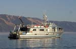 Shearwater |
Dailey, E.T., 2018, Structure-from-Motion (SfM) surface models derived from seafloor video from the Channel Islands, California: U.S. Geological Survey data release, https://www.sciencebase.gov/catalog/item/5bae6310e4b08583a5d30f7c.
FAN 2016-668-FA has data viewable in the CMGP Video and Photograph Portal. View the data in this application here. See the instructions for working with this application.
| Survey Equipment | Survey Info | Data Type(s) | Data Collected |
|---|---|---|---|
| sampling equipment | --- | Biology Chemistry Geology Experiments (biological) Sediment Properties | |
| BOB sled | --- | Photo Video | Structure-from-Motion (SfM) surface models derived from seafloor video from the Channel Islands, California (Structure-from-Motion (SfM) surface models were created using seafloor video collected over a visible fault scarp in the Channel Islands, California, during a 2016 U.S. Geological Survey (USGS) field activity. Four SfM surface models were created, each with a different combination of locating, scaling, and optimizing methods. Video imagery was collected using the USGS Pacific Coastal and Marine Science Center's BOBSled, equipped with high-definition (720p) video cameras (video published in Coastal and Marine Geology Program video and photo portal, Golden and others, 2015). ) |
| Sparker | --- | Sparker | |
| Yonav | --- | Navigation | |
| sparker | --- | Sparker |
