Other ID: none
Status: Completed
Organization(s): USGS, Woods Hole Coastal and Marine Science Center
Funding Program(s): Other (Other)
Principal Investigator(s): Jason Chaytor
Affiliate Investigator(s):
Information Specialist(s): Wayne Baldwin
Data Type(s): Location-Elevation: Navigation, Seismics: Boomer, Seismics: Multichannel, Seismics: Sparker, Seismics: Sub Bottom Profiler, Sonar: Multibeam, Sonar: Sound Velocity
Scientific Purpose/Goals: MRDF mapping proof of concept
Vehicle(s):
Start Port/Location: Gulfport, MS
End Port/Location: Gulfport, MS
Start Date: 2017-05-19
End Date: 2017-05-26
Equipment Used: Reson T20-P, Edgetech chirp subbottom profiler 512i, POS-MV, S-Boom seismic source, DGPS, Sparker , Sensor - MVP30 (Odim), GeoEel digital streamer
Information to be Derived: Bathymetry and shallow subsurface structure
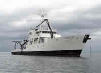
Summary of Activity and Data Gathered: High resolution bathymetric, sea-floor backscatter, and seismic-reflection data were collected offshore of southeastern Louisiana aboard the research vessel Point Sur on May 19-26, 2017, in an effort to characterize mudflow hazards on the Mississippi River Delta front. Approximately 675 kilometers (km) of multibeam bathymetry and backscatter data, 420 km of towed chirp data, and 550 km of multichannel seismic data were collected.
Staff: Seth Ackerman, Wayne Baldwin, Emile Bergeron, Jason Chaytor, William Danforth, Eric Moore, Alexander Nichols, Charles Worley
Affiliate Staff:
Notes:
Location:
Gulf of America (Gulf of Mexico)
| Boundaries | |||
|---|---|---|---|
| North: 29.43242153 | South: 28.755905 | West: -89.57427979 | East: -88.843299 |
Platform(s):
 Point Sur |
Baldwin, W.E., Ackerman, S.D., Worley, C.R., Danforth, W.W., and Chaytor, J.D, 2018, High-resolution geophysical data collected along the Mississippi River Delta front offshore of southeastern Louisiana, U.S. Geological Survey Field Activity 2017-003-FA: U.S. Geological Survey data release, https://doi.org/10.5066/F7X929K6.
Damour, M., Chaytor, J., Jones, D., Brennan, M., Bentley, S., 2024, Shipwreck Sentinels: A Novel Approach for Monitoring Subsea Mudflows on the Mississippi River Delta Front: , Ocean Sciences Meeting 2024.
Figueredo, N., Bentley, S., Chaytor, J., Xu, K., Jafari, N., Georgiou, I., Miner, M., D'amour, M., Duxbury, J., Obelcz, J., Maloney, J., 2024, Sedimentary processes and instability on the Mississippi River Delta Front near the Wreck of the SS Virginia: , Ocean Sciences Meeting 2024.
Figueredo, N., Bentley, S.J., Chaytor, J.D., Xu, K., Jafari, N., Georgiou, I.Y., Damour, M., Duxbury, J., Obelcz, J., and Maloney, J., 2024, Sedimentary Processes and Instability on the Mississippi River Delta Front near the Shipwreck of the SS Virginia: Water, 16(3), 421, https://doi.org/10.3390/w16030421.
| Survey Equipment | Survey Info | Data Type(s) | Data Collected |
|---|---|---|---|
| Reson T20-P | Approximately 675 km of raw Dual Reson T20-P multibeam bathymetry and backscatter data. | Multibeam Water column reflectivity | 2017-003-FA_T20P_Bathy_overview (Multibeam echosounder, Reson T-20P bathymetry overview (10-m) (32-bit GeoTIFF, UTM Zone 16N, NAD 83, NAVD 88 Vertical Datum)) 2017-003-FA_T20P_Bathy_deepsite (Multibeam echosounder, Reson T-20P deep site bathymetry (4-m) (32-bit GeoTIFF, UTM Zone 16N, NAD 83, NAVD 88 Vertical Datum)) 2017-003-FA_T20P_Backscatter_deepsite (Multibeam echosounder, Reson T-20P deep site backscatter (4-m) (8-bit GeoTIFF, UTM Zone 16N, NAD 83)) 2017-003-FA_T20P_Backscatter_mc20site (Multibeam echosounder, Reson T-20P MC20 site backscatter (2-m) (8-bit GeoTIFF, UTM Zone 16N, NAD 83)) 2017-003-FA_T20P_Bathy_mc20site (Multibeam echosounder, Reson T-20P MC20 site bathymetry (2-m) (32-bit GeoTIFF, UTM Zone 16N, NAD 83, NAVD 88 Vertical Datum)) 2017-003-FA_T20P_Backscatter_swpasssite (Multibeam echosounder, Reson T-20P Southwest Pass site backscatter (4-m)(8-bit GeoTIFF, UTM Zone 16N, NAD 83)) 2017-003-FA_T20P_Bathy_swpasssite (Multibeam echosounder, Reson T-20P Southwest Pass site bathymetry (8-m) (32-bit GeoTIFF, UTM Zone 16N, NAD 83, NAVD 88 Vertical Datum)) 2017-003-FA_T20P_Tracklines (Multibeam echosounder, Reson T-20P tracklines (Esri polyline shapefile, GCS WGS 84)) |
| Edgetech chirp subbottom profiler 512i | Approximately 420 km of raw Edgetech 512i chirp seismic-reflection data. | Sub Bottom Profiler | 2017-003-FA_512i_Images (Seismic reflection, EdgeTech SB-512i chirp profile images (PNG images)) 2017-003-FA_512i_500sht (Seismic reflection, EdgeTech SB-512i chirp shot points (CSV text and Esri point shapefile, GCS WGS 84)) 2017-003-FA_512i_Tracklines (Seismic reflection, EdgeTech SB-512i chirp tracklines(Esri polyline shapefile, GCS WGS 84)) |
| POS-MV | Vessel navigation and attitude data for the dual Reson T20P multibeam data were acquired with an Applanix POS MV Wavemaster (model 220, V5). | Navigation | |
| S-Boom seismic source | Applied Acoustics S-Boom was used as a source for multichannel seismic-reflection data acquisition. | Boomer | |
| DGPS | Navigation for the chirp and multichannel seismic reflection data were acquired using DGPS. | Navigation | |
| Sparker | SIG ELC 1050 and 1200 mini sparkers were used as sources for multichannel seismic-reflection data acquisition. | Sparker | |
| Sensor - MVP30 (Odim) | Water column sound velocity profiles were acquired using an Odim MVP30 moving vessel profiler. | Sound Velocity | 2017-003-FA_MVPdata (Sound velocity profiles, Odim MVP 30 sound velocity profile data (PNG images, ASVP text, and Esri point shapefile, GCS WGS 84).) |
| GeoEel digital streamer | Approximately 550 km of raw multichannel seismic reflection data shot using Applied Acoustics S-Boom or SIG mini sparker (ELC 1050 and 1200) sources powered by Applied Acoustics CSP-D (700 and 2400) power supplies, and recorded using a 150-m long 32-channel (50 m active section) solid-state Geometrics GeoEel streamer with 1.5625-m spaced groups connected to a Geometrics Streamer Power Supply Unit (SPSU). | Boomer Multichannel Sparker Air Gun / Water Gun Bubble Gun | 2017-003-FA_MCS_Images (Seismic reflection, Geometrics multi-channel streamer common midpoint brute stack profile images(PNG images)) 2017-003-FA_MCS_100cmp (Seismic reflection, Geometrics multi-channel streamer common midpoint navigation (CSV text and Esri point shapefile, GCS WGS 84)) 2017-003-FA_MCS_Tracklines (Seismic reflection, Geometrics multi-channel streamer tracklines (Esri polyline shapefile, GCS WGS 84) Dates) |