Other ID: 17SGD04
Status: Completed
Organization(s): USGS, St. Petersburg Coastal and Marine Science Center
Funding Program(s): Coastal Aquifer Project - CAPII (GR.18.MN00.GVK11.00)
Principal Investigator(s): Christopher Smith
Affiliate Investigator(s):
Information Specialist(s): Cheyenne Everhart
Data Type(s): Electro-Magnetic: Resistivity, Environmental Data: Conductivity, Environmental Data: CTD, Environmental Data: Depth, Environmental Data: Dissolved Oxygen, Environmental Data: ORP, Environmental Data: pH, Environmental Data: Radon, Environmental Data: Sediment Properties, Environmental Data: Temperature, Location-Elevation: Navigation, Sampling: Geology
Scientific Purpose/Goals: To map radon, water quality parameters and CRP data to better understand submarine groundwater discharge.
Vehicle(s): Chevy Suburban Silver, Ford F-350 Dually White (GSA)
Start Port/Location: St.Petersburg, Florida
End Port/Location: Melbourne, Florida
Start Date: 2017-07-26
End Date: 2017-08-02
Equipment Used: Continuous Resistivity Profiler (CRP), Conductivity, Temperature, and Depth (CTD) Probe, Solinst Levelogger (LTC), Other, HOBO Water Temperature Pro V2 Data Logger, YSI Professional Plus Multiparameter Meter, Rad 7 Radon Detector, Garmin GPS, Grab Sampler
Information to be Derived: Will map radon concentrations using rad-7, will collect YSI data in conjunction with rad-7 data and continuous restivity profile.
Summary of Activity and Data Gathered: Collected 30 CRP profiles.
Staff: Cheyenne Everhart, Christopher Smith
Affiliate Staff:
Notes:
Location:
Indian River Lagoon
| Boundaries | |||
|---|---|---|---|
| North: 28.28696063 | South: 28.03664269 | West: -80.70590973 | East: -80.56095956 |
Platform(s):
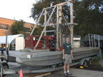 Barge |
Everhart, C.S., McBride, E.C., Zaremba, N.J., Nelson, P.R., McCloskey, T.A., Smith, C.G., Flint, M.K., 2018, Radon-222 and water column data related to submarine groundwater discharge along the western margin of Indian River Lagoon, FloridaâSeptember 2016 to July 2017 (ver. 2.0, March 2018): U.S. Geological Survey data release, https://doi.org/10.5066/F7QF8S05.
Forde, A.S., Smith, C.G., Zaremba, N.J., McBride, E.C., 2018, Continuous resistivity profiling, electrical resistivity tomography and hydrologic data collected in 2017 from Indian River Lagoon, Florida: U.S. Geological Survey data release, https://doi.org/10.5066/F7V40TFH.
| Survey Equipment | Survey Info | Data Type(s) | Data Collected |
|---|---|---|---|
| Continuous Resistivity Profiler (CRP) | --- | Resistivity | resistivity_CRP.zip (Continuous resistivity profiling measurements, location, and water column data collected between March and October 2017) |
| Conductivity, Temperature, and Depth (CTD) Probe | --- | CTD | |
| Solinst Levelogger (LTC) | --- | CTD | |
| Other | --- | --- | --- |
| HOBO Water Temperature Pro V2 Data Logger | --- | Temperature | |
| YSI Professional Plus Multiparameter Meter | --- | Conductivity Depth Dissolved Oxygen Nitrate ORP pH Temperature | |
| Rad 7 Radon Detector | --- | Radon | IRL_July_2017 (Radon-222, physical water column properties, and GIS data ) |
| Garmin GPS | --- | Navigation | |
| Grab Sampler | --- | Biology Geology |
