Other ID: none
Status: Completed
Organization(s): USGS, Woods Hole Coastal and Marine Science Center
Funding Program(s): CMG-WH Core Competency - Marine Technology (LQ000GU)
Principal Investigator(s): Seth Ackerman, Dann Blackwood
Affiliate Investigator(s): Roman Zajac (Univ of New Haven) Ivar Babb (Univ of Conn)
Information Specialist(s): Seth Ackerman
Data Type(s): Imagery: Photo, Imagery: Video, Sampling: Geology
Scientific Purpose/Goals: To collect ground truth sediment samples, video and photographs to help characterize the seafloor geology and biota
Vehicle(s):
Start Port/Location: Groton/Avery Point, CT
End Port/Location: Groton/Avery Point, CT
Start Date: 2018-05-07
End Date: 2018-05-16
Equipment Used: GoPro camera, SeaBOSS, Nikon D300, Osprey camera system
Information to be Derived: grain size, seafloor character
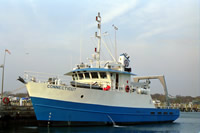
Summary of Activity and Data Gathered: SEABOSS operations were conducted in Long Island Sound aboard the R/V Connecticut from May 8-15, 2018 as part of an agreement with LISMaRC project, partnered with scientists at UConn and Univ of New Haven. A total of 117 sampling sites were occupied during the survey where videos, still photographs and sediment samples were collected using the Interocean version of the SEABOSS. Navigation was determined using a WAAS-enabled Garmin GPSMAP 76C GPS receiver that was located approximately 3 meters away from the SEABOSS deployment point.
Staff: Seth Ackerman, Dann Blackwood
Affiliate Staff:
Notes: SEABOSS operations will be conducted in Long Island Sound aboard the R/V Connecticut as part of an agreement with Univ of Connecticut (LISMaRC project) to map the geology and biota of Long Island Sound. This work is in conjunction with additional collaborators from University of New Haven and Lamont Doherty Earth Observatory (Columbia University).
Entries for this field activity are based on entries from Field Activity 2017-056-FA
Location:
Long Island Sound, Connecticut, United States, Atlantic Ocean
| Boundaries | |||
|---|---|---|---|
| North: 41.35124751 | South: 41.07348081 | West: -72.59326179 | East: -71.79809577 |
Platform(s):
 Connecticut |
Ackerman, S.D., Huntley, E.C., Blackwood, D.S., Babb, I.G., Zajac, R.N., Conroy, C.W., Auster, P.J., Schneeberger, C.L., and Walton, O.L., 2020, Sea-floor sediment and imagery data collected in Long Island Sound, Connecticut and New York, 2017 and 2018: U.S. Geological Survey data release, https://doi.org/10.5066/P9GK29NM.
| Survey Equipment | Survey Info | Data Type(s) | Data Collected |
|---|---|---|---|
| GoPro camera | GoPro HERO4 Black camerarecording backup video mounted on the SEABOSS. Attached to Nikon housing to capture still images when the photosea strobe stopped working. | Photo Video | |
| SeaBOSS | The SEABed Observation and Sampling System (SEABOSS) was used to collect sediment samples with a modified Van Veen sampler and video and still images of the seabed with cameras mounted on the SEABOSS frame. | Surveys (biological) Experiments (biological) Species ID Photo Video Geology Biology | |
| Nikon D300 | Digital still camera with a Photosea strobe mounted on the SEABOSS. Strobe stopped working on the cruise. | Photo | |
| Osprey camera system | Kongsberg Simrad OE1365 video camera on the SEABOSS (high-resolution CCD color camera). | Photo Video |