Other ID: none
Status: Cancelled
Organization(s): USGS, Woods Hole Coastal and Marine Science Center
Funding Program(s): Sound Source Verification (LQ000GU)
Principal Investigator(s): David Foster, Charles Worley
Affiliate Investigator(s):
Information Specialist(s): Wayne Baldwin, David Foster
Data Type(s): Seismics: Boomer, Seismics: Bubble Gun, Seismics: Sparker, Sonar: Multibeam, Sonar: Sound Velocity
Scientific Purpose/Goals: Test multibeam and seismic reflection systems for upcoming field work.
Vehicle(s):
Start Port/Location: Cataumet, MA
End Port/Location: Cataumet, MA
Start Date: 2018-04-30
End Date: 2018-05-11
Equipment Used: Other
Information to be Derived: Data for QA/QC to assure systems are working properly.
Summary of Activity and Data Gathered:
Staff: Wayne Baldwin, Barry Irwin, Alexander Nichols, Charles Worley
Affiliate Staff:
Notes: Finding: Marine Tech/Seafloor Mapping
Account is GX.18.LQ00.0GU10.00
The seismic receiver being used with all sources is a 24-channel Geoeel (solid) streamer (1.25 m group)
Location:
Buzzards Bay, Massachusetts, United States, Atlantic Ocean
| Boundaries | |||
|---|---|---|---|
| North: 41.76665589 | South: 41.46852409 | West: -70.88832793 | East: -70.60143557 |
Platform(s):
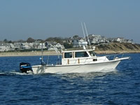
 Rafael |
| Survey Equipment | Survey Info | Data Type(s) | Data Collected |
|---|---|---|---|
| Other | --- | --- | --- |