Other ID: none
Status: Completed
Organization(s): USGS, St. Petersburg Coastal and Marine Science Center
Funding Program(s): Coastal Hazards (GX.20.MN00.E3R60.00)
Principal Investigator(s): Patricia (Soupy) Dalyander, Kimberly Yates
Affiliate Investigator(s):
Information Specialist(s): Legna Torres-Garcia
Data Type(s): Sampling: Geology, Time Series: Mooring (physical oceanography)
Scientific Purpose/Goals: To service an instrument (OBS).
Vehicle(s): Ford F-350 Dually White (GSA)
Start Port/Location: St. Petersburg, FL
End Port/Location: Islamorada, FL
Start Date: 2018-01-23
End Date: 2018-01-25
Equipment Used: Other, Other
Information to be Derived: Grain distribution, suspended sediment concentration
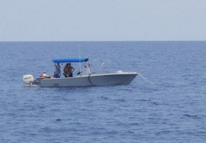
Summary of Activity and Data Gathered: During this trip we service the turbidity sensor and move it to a different location to avoid malfunction. We took pictures of the area.
Staff: Christopher Moore, Legna Torres-Garcia, Hunter Wilcox
Affiliate Staff:
Notes: Entries for this field activity are based on entries from Field Activity 2018-301-FA
Location:
Crocker Reef, Islamorada, Florida, United States, Atlantic Ocean
| Boundaries | |||
|---|---|---|---|
| North: 24.900256 | South: 24.87441346 | West: -80.62763214 | East: -80.58499215 |
Platform(s):
 Halimeda |
| Survey Equipment | Survey Info | Data Type(s) | Data Collected |
|---|---|---|---|
| Other | --- | --- | --- |
| Other | --- | --- | --- |