AKA: none
Other ID: none
Status: Completed
Organization(s): USGS, Pacific Coastal and Marine Science Center
Funding Program(s): Tsunami Hazards, Modeling, and the Sedimentary Record (ZP00ES5)
Principal Investigator(s): SeanPaul La Selle, Andrew Stevens
Affiliate Investigator(s):
Information Specialist(s): SeanPaul La Selle, Andrew Stevens
Data Type(s): Imagery: Photo, Location-Elevation: Navigation, Location-Elevation: Transects, Sampling: Geology, Sonar: Sidescan, Sonar: Single Beam, Sonar: Sound Velocity
Scientific Purpose/Goals: To collect bathymetric data and information on the lake substrate in order to guide coring efforts searching for paleo-tsunami deposits.
Vehicle(s): MarFac; Chevy Suburban - gray; 7 pass; G62-2874L
Start Port/Location: Port Orford, OR
End Port/Location: Port Orford, OR
Start Date: 2018-06-17
End Date: 2018-06-23
Equipment Used: Echosounder-1 (Odom Echotrac CV-100), Radio (base), Waverunners, camera, Trimble R7 GPS receiver, Ponar grab sampler, Starfish, soundvelocityprofiler
Information to be Derived: Lake bathymetry, lakebed backscatter intensity
Summary of Activity and Data Gathered: base, field_notes, hypack, matlab, photos, and SVP data submitted to FAD by Andrew Stevens 6/22/2018
Staff: Jackson Currie
Affiliate Staff:
Notes:
Location:
Floras Lake, Oregon
| Boundaries | |||
|---|---|---|---|
| North: 42.90992204 | South: 42.88060281 | West: -124.51939735 | East: -124.48570493 |
Platform(s):
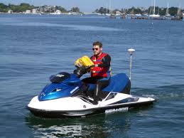
 Waverunner 1 (SC) |  Waverunner 2 (SC) |
La Selle, S.M., Stevens, A.W., and Nasr, B.M., 2023, Bathymetry data from Floras Lake, Oregon, June 2018: U.S. Geological Survey , https://doi.org/10.5066/P9FQQ5JN.
La Selle, S.M., Stevens, A.W., and Nasr, B.M., 2023, Bathymetry and acoustic backscatter data from Floras Lake, Oregon, June 2018: U.S. Geological Survey data release, https://doi.org/10.5066/P9FQQ5JN.
| Survey Equipment | Survey Info | Data Type(s) | Data Collected |
|---|---|---|---|
| Echosounder-1 (Odom Echotrac CV-100) | --- | Single Beam | Bathymetry data from Floras Lake, Oregon, June 2018 (Bathymetry data collected during surveys performed in Floras Lake, Oregon in June 2018.) |
| Radio (base) | --- | Benchmarks LIDAR Navigation Profiles Transects | |
| Waverunners | --- | Navigation Single Beam | |
| camera | --- | Photo | |
| Trimble R7 GPS receiver | --- | Benchmarks LIDAR Navigation Profiles Transects | |
| Ponar grab sampler | --- | Biology Chemistry Geology | |
| Starfish | --- | Sidescan | Acoustic-backscatter data (This portion of the USGS data release presents acoustic-backscatter data collected during surveys performed in Floras Lake, Oregon in June 2018 (USGS Field Activity Number 2018-636-FA).) |
| soundvelocityprofiler | --- | Sound Velocity |