AKA: none
Other ID: Bay toll crossing
Status: Completed
Organization(s): USGS, Pacific Coastal and Marine Science Center
Funding Program(s): Other (Other)
Data Source Information: Caltrans
Information Specialist(s): Mary McGann
Data Type(s): Location-Elevation: Navigation, Sampling: Geology
Start Date: 1965-01-01
End Date: 1980-12-31
Equipment Used: navigation, core
Information to be Derived: physical core samples
Summary of Activity and Data Gathered: 30 pallets of cores in 1030 OBrien warehouse
Notes: Sample locations digitized from publication; data on FAD
Selby cores taken in preparation for Bay Bridge pier locations.
Location:
San Francisco Bay, California
| Boundaries | |||
|---|---|---|---|
| North: 37.8342008 | South: 37.4472521 | West: -122.48464336 | East: -122.0231827 |
Platform(s):
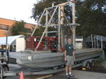 Barge |
Atwater, B.F., Hedel, C.H., and Helley, E.J., 1977, Late Quaternary Depositional History, Holocene Sea-Level Changes, and Vertical Crustal Movement, Southern San Francisco Bay, California: U. S. Geological Survey Professional Paper 1014.
| Survey Equipment | Survey Info | Data Type(s) | Data Collected |
|---|---|---|---|
| navigation | --- | Navigation | |
| core | --- | Biology Geology |
