AKA: none
Other ID: none
Status: Completed
Organization(s): USGS, Pacific Coastal and Marine Science Center
Funding Program(s): Climate Change Impacts to the U.S. Pacific and Arctic Coasts (ZP00F00)
Principal Investigator(s): Patrick Barnard, Jonathan Warrick
Affiliate Investigator(s):
Information Specialist(s): Alexander Snyder, Andrew Stevens
Data Type(s): Imagery: Photo, Location-Elevation: Navigation, Location-Elevation: Profiles, Sonar: Single Beam, Sonar: Sound Velocity
Scientific Purpose/Goals: Collect nearshore bathymetry and beach topography in Monterey Bay
Vehicle(s): Ford Explorer - Blue - G62-2733K, Grand Caravan G41-3720L, MarFac; Chevy Suburban - gray; 7 pass; G62-2874L, MarFac; Expedition G62-3094P, Mitsubishi Outlander G61-0912R
Start Port/Location: Santa Cruz, CA
End Port/Location: Moss Landing, CA
Start Date: 2019-03-04
End Date: 2019-03-11
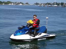
Equipment Used: camera, Trimble R10 GPS (AS), Trimble R7 GPS (AS), Trimble R7 GPS receiver, Trimble R7 GPS receiver 9, Waverunners, YSI Sound velocity CTD
Information to be Derived: Nearshore bathymetry, beach topography
Summary of Activity and Data Gathered: Beach topography and nearshore bathymetry collected during multiple days.
Staff: Patrick Barnard, Jackson Currie, Timothy Elfers, Amy Foxgrover, Daniel Hoover, Cordell Johnson, Joshua Logan, Rachel Marcuson, Brandon (Contractor) Nasr, Schuyler (Contractor) Smith, Alexander Snyder, Andrew Stevens, Rae Taylor-Burns, Sean Vitousek, Jonathan Warrick
Affiliate Staff:
Notes: Local Fieldwork, NO OT
Entries for this field activity are based on entries from Field Activity 2018-677-FA
Location:
Monterey Bay
| Boundaries | |||
|---|---|---|---|
| North: 36.99816566 | South: 36.80973309 | West: -122.097 | East: -121.75476074 |
Platform(s):
 Waverunner 1 (SC) |  Waverunner 2 (SC) |
Snyder, A.G., Stevens, A.W., Logan, J.B., and Hoover, D.J., 2024, Digital elevation models (DEMs) of the beach and nearshore in Santa Cruz, California: U.S. Geological Survey data release, https://doi.org/10.5066/P134BC6W.
| Survey Equipment | Survey Info | Data Type(s) | Data Collected |
|---|---|---|---|
| camera | --- | Photo | |
| Trimble R10 GPS (AS) | --- | Navigation Profiles | |
| Trimble R7 GPS (AS) | --- | Benchmarks Navigation Profiles Transects | |
| Trimble R7 GPS receiver | --- | Benchmarks LIDAR Navigation Profiles Transects | |
| Trimble R7 GPS receiver 9 | --- | Benchmarks LIDAR Navigation Profiles Transects | |
| Waverunners | --- | Navigation Single Beam | |
| YSI Sound velocity CTD | --- | Sound Velocity |