AKA: none
Other ID: none
Status: Completed
Organization(s): USGS, Pacific Coastal and Marine Science Center
Funding Program(s): Sediment Transport in Coastal Environments (ZP00FDB)
Principal Investigator(s): Andrew Stevens
Affiliate Investigator(s): Peter Ruggiero (OSU) George Kaminsky (WA DOE)
Information Specialist(s): Andrew Stevens
Data Type(s): Location-Elevation: Benchmarks, Location-Elevation: Navigation, Location-Elevation: Profiles, Sonar: Single Beam
Scientific Purpose/Goals: Collect nearshore bathymetry and beach topography in the Columbia River littoral cell.
Vehicle(s): MarFac; Expedition G62-3094P
Start Port/Location: Astoria, OR
End Port/Location: Ocean Shores, WA
Start Date: 2019-07-29
End Date: 2019-08-16
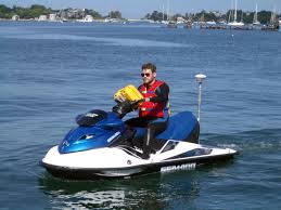
Equipment Used: Radio (base), Trimble R7 GPS (AS), GPS, Waverunners
Information to be Derived: Beach Topography, Nearshore Bathymetry
Summary of Activity and Data Gathered: Bathymetry and topography collected successfully over multiple days.
Staff: Jackson Currie, Timothy Elfers, Jennifer McKee
Affiliate Staff:
Notes: Entries for this field activity are based on entries from Field Activity 2018-652-FA
Location:
Columbia River Littoral Cell
| Boundaries | |||
|---|---|---|---|
| North: 47.13742465 | South: 45.99696162 | West: -124.59594727 | East: -123.76098633 |
Platform(s):
 Waverunner 1 (SC) |  Waverunner 2 (SC) |
Stevens, A.W., Weiner, H.M., Ruggiero, P., Kaminsky, G.M., and Gelfenbaum G.R., 2019, Beach topography and nearshore bathymetry of the Columbia River littoral cell, Washington and Oregon (ver. 2.0, November 2019): U.S. Geological Survey data release, https://doi.org/10.5066/P9W15JX8.
| Survey Equipment | Survey Info | Data Type(s) | Data Collected |
|---|---|---|---|
| Radio (base) | --- | Benchmarks LIDAR Navigation Profiles Transects | |
| Trimble R7 GPS (AS) | --- | Benchmarks Navigation Profiles Transects | Beach topography of the Columbia River littoral cell, Washington and Oregon, 2019 (This portion of the USGS data release presents topography data collected during surveys performed in the Columbia River littoral cell, Washington and Oregon, in 2019 (USGS Field Activity Number 2019-632-FA). Topographic profiles were collected by walking along survey lines with global navigation satellite system (GNSS) receivers mounted on backpacks. Prior to data collection, vertical distances between the GNSS antennas and the ground were measured using a tape measure. Hand-held data collectors were used to log raw data and display navigational information allowing surveyors to navigate survey lines spaced at 100- to 1000-m intervals along the beach. Profiles were surveyed from the landward edge of the study area (either the base of a bluff, engineering structure, or just landward of the primary dune) over the beach foreshore, to wading depth on the same series of transects as nearshore bathymetric surveys that were conducted during the same time period. Additional topographic data were collected between survey lines in some areas with an all-terrain vehicle (ATV) equipped with a GNSS receiver to constrain the elevations and alongshore extent of major morphological features. ) |
| GPS | --- | Navigation | |
| Waverunners | --- | Navigation Single Beam | Nearshore bathymetry of the Columbia River littoral cell, Washington and Oregon, 2019 (This portion of the USGS data release presents bathymetry data collected during surveys performed in the Columbia River littoral cell, Washington and Oregon in 2019 (USGS Field Activity Number 2019-632-FA). Bathymetry data were collected using four personal watercraft (PWCs) equipped with single-beam sonar systems and global navigation satellite system (GNSS) receivers. ) |