AKA: Cascadia seafloor geodesy
Other ID: none
Status: Completed
Organization(s): Other
Funding Program(s): Other (Other)
Principal Investigator(s): Janet Watt
Affiliate Investigator(s): David Chadwell (SIO) Ben Brooks, Todd Erickson (USGS-EHP-Menlo Park) David Schmidt (UW)
Information Specialist(s): Other
Data Type(s): Location-Elevation: Navigation
Scientific Purpose/Goals: Determine coupling rates on offshore faults in the Cascadia subduction zone using seafloor geodesy
Vehicle(s): None
Start Port/Location: Eureka, CA
End Port/Location: Eureka, CA
Start Date: 2019-08-08
End Date: 2019-08-14
Equipment Used: GPS
Information to be Derived: seafloor GPS-A
Summary of Activity and Data Gathered: Four seafloor GPS-A sites were visited and equipment was recovered/checked. At the Newport and Grays Harbor sites, 3 seafloor transponders were recovered; status of 2 transponders were checked at the Cape Lookout site; status of 2 transponders at Coos Bay site were checked; Wave glider was recovered at Newport site.
Staff: Robert Wyland
Affiliate Staff:
Notes: This work is being done in collaboration with Ben Brooks (USGS-EHP), David Chadwell (SIO), and David Schmidt (UW). David Chadwell is the cruise PI and all equipment will be provided by USGS-Menlo Park, SIO, and UW. PCMSC's Rob Wyland will be trained in seafloor GPS-A and provide ET support.
Location:
Cascadia margin
| Boundaries | |||
|---|---|---|---|
| North: 48.22467265 | South: 41.9676592 | West: -126.2109375 | East: -123.48632813 |
Platform(s):
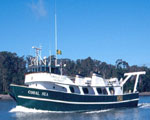
 Coral Sea |
| Survey Equipment | Survey Info | Data Type(s) | Data Collected |
|---|---|---|---|
| GPS | GPS-A seafloor geodetic instruments | Navigation |