AKA: none
Other ID: CRADA Hosgri coring project
Status: Completed
Organization(s): USGS, Pacific Coastal and Marine Science Center
Funding Program(s): Coastal and marine earthquake, tsunami, and landslide active margin field studies (ZP00EQV)
Principal Investigator(s): Jared Kluesner
Affiliate Investigator(s):
Information Specialist(s): Alicia Balster-gee
Data Type(s): Seismics: Multichannel, Location-Elevation: Navigation, Sampling: Geology, Seismics: Sparker, Seismics: Sub Bottom Profiler
Scientific Purpose/Goals: To collect sediment cores and CHIRP data to asses sediment ages and slip rates along the Hosgri Fault Zone.
Vehicle(s): MarFac; Ford 650 Box truck - White G71-03559
Start Port/Location: Oakland, CA
End Port/Location: San Diego, CA
Start Date: 2019-10-18
End Date: 2019-10-24
Equipment Used: Multichannel, Differential GPS, Vibracore, 512 chirp-source, Other, 512 chirp, Mini sparker
Information to be Derived: sediment thickness and sediment age, grain size
Summary of Activity and Data Gathered: 36 chirp profiles (65 profiles including turns and line parts), 32 multichannel minisparker profiles, and 23 vibracores from 20 locations.
Staff:
Affiliate Staff:
Notes:
Location:
Offshore Morro Bay
| Boundaries | |||
|---|---|---|---|
| North: 35.77579932 | South: 34.56729133 | West: -121.43364429 | East: -120.61263084 |
Platform(s):
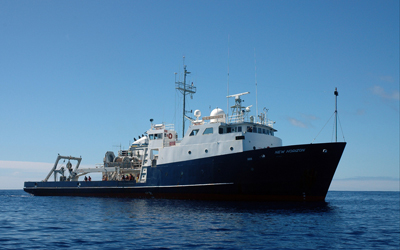 Bold Horizon |
Snyder, G.R., Balster-Gee, A.F., Kluesner, J.W., Johnson, S.Y., Media, E., Simms, A., Nishenko, S., Greene, G., Conrad, J.E., 2022, Geophysical and core sample data collected offshore central California, during field activity 2019-651-FA: U.S. Geological Survey data release, https://doi.org/10.5066/P9A0U8J7.
Snyder, G.R., Balster-Gee, A.F., Kluesner, J.W., Johnson, S.Y., Medri, E., Simms, A., Nishenko, S., Greene, G., and Conrad, J.E., 2023, Geophysical and core sample data collected offshore central California, during field activity 2019-651-FA: U.S. Geological Survey data release, https://doi.org/10.5066/P9A0U8J7.
| Survey Equipment | Survey Info | Data Type(s) | Data Collected |
|---|---|---|---|
| Multichannel | --- | Multichannel | Multichannel seismic-reflection and navigation data (Multichannel seismic-reflection data and associated navigation files were collected offshore central California in the vicinity of Morro Bay. These data were collected aboard the M/V Bold Horizon in October 2019 for use in regional hazard assessments relating to the Hosgri Fault.) |
| Differential GPS | --- | Navigation | |
| Vibracore | --- | Chemistry Geology | Radiocarbon age data from vibracores (This dataset includes radiocarbon age data from sediment cores collected offshore central California in the vicinity of Morro Bay. These data were collected aboard the M/V Bold Horizon in October 2019 for use in regional hazard assessments relating to the Hosgri Fault.) Optically stimulated luminescence (OSL) age data from vibracores (This dataset includes optically stimulated luminescence (OSL) age data from sediment cores collected offshore central California in the vicinity of Morro Bay. These data were collected aboard the M/V Bold Horizon in October 2019 for use in regional hazard assessments relating to the Hosgri Fault.) Coordinates of vibracores (This dataset includes coordinate information for sediment cores collected offshore central California in the vicinity of Morro Bay. These data were collected aboard the M/V Bold Horizon in October 2019 for use in regional hazard assessments relating to the Hosgri Fault.) Computed tomography (CT) scans of vibracores (This dataset includes computed tomography (CT) scans of sediment cores collected offshore central California in the vicinity of Morro Bay. These data were collected aboard the M/V Bold Horizon in October 2019 for use in regional hazard assessments relating to the Hosgri Fault.) Multi-sensor core logger (MSCL) data of vibracores (This dataset includes multi-sensor core logger (MSCL) data from sediment cores collected offshore central California in the vicinity of Morro Bay. The sediment cores were collected aboard the M/V Bold Horizon in October 2019 for use in regional hazard assessments relating to the Hosgri Fault.) Grain-size data of vibracores (This dataset includes grain-size data of sediment cores collected offshore central California in the vicinity of Morro Bay. These data were collected aboard the M/V Bold Horizon in October 2019 for use in regional hazard assessments relating to the Hosgri Fault.) Photographs of vibracores (This dataset includes photographs of sediment cores collected offshore central California in the vicinity of Morro Bay. These data were collected aboard the M/V Bold Horizon in October 2019 for use in regional hazard assessments relating to the Hosgri Fault.) Mineralogical point-count data from vibracores (This dataset includes mineralogical point-count data from sediment cores collected offshore central California in the vicinity of Morro Bay. These data were collected aboard the M/V Bold Horizon in October 2019 for use in regional hazard assessments relating to the Hosgri Fault.) |
| 512 chirp-source | --- | Sub Bottom Profiler | |
| Other | --- | --- | --- |
| 512 chirp | --- | Sub Bottom Profiler | CHIRP seismic-reflection and navigation data (CHIRP seismic-reflection data and associated navigation files were collected offshore central California in the vicinity of Morro Bay. These data were collected aboard the M/V Bold Horizon in October 2019 for use in regional hazard assessments relating to the Hosgri Fault.) |
| Mini sparker | --- | Sparker |
