Other ID: none
Status: Completed
Organization(s): USGS, Woods Hole Coastal and Marine Science Center
Funding Program(s): CMG-WH Core Competency - Marine Technology (LQ000GU)
Principal Investigator(s): Jason Chaytor, Uri Ten Brink
Affiliate Investigator(s):
Information Specialist(s): Wayne Baldwin
Data Type(s): Location-Elevation: Navigation, Environmental Data: Depth, Seismics: Sparker
Scientific Purpose/Goals: To identify the location and geometry of the fault(s) that ruptured to produce the M 6.4 mainshock, and the foreshocks and aftershocks using a sparker source and a high-resolution multichannel seismic streamer.
Vehicle(s):
Start Port/Location: UPRM Marine Laboratoy Isla Magueyez, La Parguera, PR
End Port/Location: UPRM Marine Laboratoy Isla Magueyez, La Parguera, PR
Start Date: 2020-03-07
End Date: 2020-03-13
Equipment Used: WAAS/DGPS, Sparker , GeoEel digital streamer, RBRsolo-D depth logger
Information to be Derived: Seismic data to identify location and geometry of faults that reuptured to produce the M 6.4 mainshock, and the foreshocks and aftershocks.
Summary of Activity and Data Gathered: Approximately 250 kilometers of multichannel seismic-reflection profile data were collected between March 7 and 13, 2020 offshore of Southwest Puerto Rico between La Parguera and Ponce. The seismic data were acquired across portions of the insular shelf and the Caribbean Sea in the vicinity of Guayanilla Canyon using sparker sources and a digital 32-channel hydrophone streamer.
Staff: Wayne Baldwin, Jason Chaytor, Eric Moore, Alexander Nichols, Uri Ten Brink
Affiliate Staff:
Notes: According to Wayne, equipment used: Geometrics GeoEel 32-channel streamer (1.5625 m groups); Applied Acoustics Delta sparker; SIG ELC minisparker; RBR Solo-D pressure depth loggers.
Location:
Southwest Puerto Rico, La Parguera, Guanica, Guayanilla, Ponce, Caribbean Sea, Guayanilla Canyon
| Boundaries | |||
|---|---|---|---|
| North: 17.993957 | South: 17.778188 | West: -67.03645 | East: -66.581641 |
Platform(s):
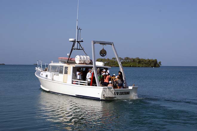 R/V Sultana |
Baldwin, W.E., Chaytor, J.D., Foster, D.S., Moore, E.M., Nichols, A.R., and ten Brink, U.S., 2021, Multichannel seismic-reflection and navigation data collected using SIG ELC1200 and Applied Acoustics Delta Sparkers and Geometrics GeoEel Digital Streamers during U.S. Geological Survey Field Activity 2020-014-FA, southwest of Puerto Rico, March 2020: U.S. Geological Survey data release, https://doi.org/10.5066/P96GY6TQ.
| Survey Equipment | Survey Info | Data Type(s) | Data Collected |
|---|---|---|---|
| WAAS/DGPS | Hemisphere R131 Differential and WAAS (Wide Angle Augmentation System) enabled GPS receiver, with the navigational reference point antenna mounted on the mast atop the wheelhouse of the R/V Sultana. | Navigation | |
| Sparker | The data associated with this system is attached to the GeoEel streamer. Multichannel seismic-reflection data were shot using multi-electrode sparker arrays (SIG ELC1200 in water depths < 100 m and Applied Acoustics Delta in water depths > 100 m) powered by an Applied Acoustics CPS-D power supply that was set to output between 200 and 2400 Joules. | Sparker | |
| GeoEel digital streamer | Geometrics GeoEel digital streamer connected to a Geometrics Streamer Power Supply Unit (SPSU). Four 12.5 m solid state sections (1.5625 m group spacing) composed an active section of 50 m and 32 channels. | Boomer Multichannel Sparker Air Gun / Water Gun Bubble Gun | 2020-014-FA_MCS_cmpTracklines (Shapefile containing multichannel seismic common mid-point tracklines.) 2020-014-FA_MCS_cmpnav.csv (Comma-separated formatted text file containing all multichannel seismic common mid-point navigation.) 2020-014-FA_MCS_shtnav.csv (Comma-separated formatted text file containing all multichannel seismic shot points.) 2020-014-FA_MCS_Images.zip (Compressed zip archive of processed multichannel seismic profile images in PNG format.) 2020-014-FA_MCS_Segy.zip (Compressed zip archive of processed multichannel seismic profiles in SEG-Y format.) 2020-014-FA_MCS_cmp500 (Shapefile containing multichannel seismic common mid-points (500 CMP reference interval).) |
| RBRsolo-D depth logger | 4 RBR solo depth loggers were spaced along the length of the active seismic streamer sections to log streamer depths during acquisition | Depth |
