Other ID: none
Status: Completed
Organization(s): USGS, Woods Hole Coastal and Marine Science Center
Funding Program(s): Coastal Model Applications and Field Measurements (LQ00DYN)
Principal Investigator(s): Christopher Sherwood
Affiliate Investigator(s): Peter Traykovski (WHOI)
Information Specialist(s): Jin-Si Over
Data Type(s): Imagery: Other Imagery, Imagery: Photo, Location-Elevation: Navigation, Location-Elevation: Transects, Sampling: Geology, Sonar: Single Beam
Scientific Purpose/Goals: Collect external camera calibration data for CACO01 cameras (target coordinates); subaerial survey measurements to map beach; aerial imagery from kite to map beach; bathymetric soundings from WHOI autonomous surface vehicle to map nearshore.
Vehicle(s):
Start Port/Location: Truro, MA
End Port/Location: Truro, MA
Start Date: 2020-03-04
End Date: 2020-03-10
Equipment Used: Argus camera system, Echosounder ECS 24D, PPK GPS, Spectra Precision SP80, Aeropoint targets, Plywood targets, Ricoh GR II, Sampling scoop
Information to be Derived: Location and orientation of the CACO01 CoastCam cameras; topography and bathymetry of the beach and nearshore region in view of the camera.
Summary of Activity and Data Gathered: March 4: 0) Established single-point localization using pre-established reference points in the parking lot 1) Measured location of CACO01 cameras with GNSS 2) Deployed plywood targets at several locations within view of cameras, recorded locations with GNSS, moved them several times 3) Conducted foot survey of beach in view of camera with GNSS 4) Collected sediment samples for analysis. March 6: 0) Deployed aeropoint targets 1) Collected aerial imagery to map subaerial beach in view of cameras using kitesurfing kites March 10: Conducted bathymetric mapping of nearshore region in view of cameras with echosounder attached to autonomous vessel built by Peter Traykovski of WHOI (has ppk GNSS system attached as well)
Staff: Jonathan Borden, Sandra Brosnahan, Eric Marsjanik, Marinna Martini, Jin-Si Over, Christopher Sherwood
Affiliate Staff:
Notes: FA is to collect GPS derived elevation data at the head of the meadows site. The team will run transects on the beach, and place aeropoint targets in view of the ARGUS camera system.
Three field days: foot survey and camera targets on March 4, kite survey on March 6, bathy survey on March 10.
Location:
Head of the Meadow beach, Truro, MA
| Boundaries | |||
|---|---|---|---|
| North: 42.05829637 | South: 42.04986271 | West: -70.08077622 | East: -70.07215023 |
Platform(s):
 on foot | 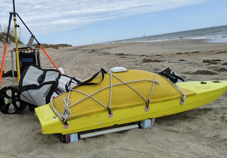 WHOI SSV |
Hill, J., Sherwood, C., 2024, Measuring coastal change through photogrammetry at Head of the Meadow Beach in Truro, Massachusetts [abs.]: , Ocean Sciences Meeting 2024.
Over, J.R., Sherwood, C.R., Traykovski, P.A., Brosnahan, S.M., Martini, M.A., Marsjanik, E., Borden, J.S., 2021, Topographic and bathymetric data, sediment samples, and beach imagery collected at Head of the Meadow, Truro in March 2020, U.S Geological Survey Field Activity 2020-015-FA (ver. 2, December 2023) U.S Geological Survey data release, https://doi.org/10.5066/P9KSG1RQ.
Over, J.R., Sherwood, C.R., Marsjanik, E.D., Borden, J.S., Martini, M.A., and Lange, A.M.Z., 2026, USGS CoastCam CACO-01 at Head of the Meadow Beach, Cape Cod National Seashore, Massachusetts (2019 to 2024)—Imagery and Calibration Data: U.S. Geological Survey data release, https://doi.org/10.5066/P95C0DGM.
Sherwood, C.R., Aretxabaleta, A.L., Traykovski, P.A., Over, J.R., Foster, D.S., Miselis, J.L., Nelson, T., 2023, INFLUENCE OF SAND BARS ON RUNUP VARIABILITY: , Coastal Sediments 2023.
Sherwood, C.R., Aretxabaleta, A.L., Traykovski, P.A., Over, J.R., Lyons, E.O., Foster, D.S., Miselis, J.L., Nelson, T.R., Sogut, E., 2023, Contributions to uncertainty in runup forecasts: , Proceedings of Coastal Sediment 2023. doi: 10.1142/9789811275135_0037.
Sherwood, C.R., Foster, D.S., Miselis, J.L., Over, J.R., Marsjanik, E.D., Traykovski, P., 2022, Variability of Cape Cod Bars: Changes over Space and Time: , Cape Cod National Seashore 2022 Science in the Seashore Symposium.
| Survey Equipment | Survey Info | Data Type(s) | Data Collected |
|---|---|---|---|
| Argus camera system | --- | Other Imagery Video | |
| Echosounder ECS 24D | Attached to SSV-Small Surf Vessel, Echologger ECS D24 used to collect bathymetry data in view of the CoastCam cameras on Head of the Meadow Beach. | Single Beam | 2020015FA_Truro_bathymetry (Single-beam bathymetry taken with echosounder mounted on autonomous surf vehicle (1-meter resolution cloud optimized 32-bit float GeoTIFF in UTM Zone 19N and Trackline data in CSV format)) |
| PPK GPS | An Emlid Reach M2 was attached/hot shoed to the Richo GR II to take a GPS position every time a picture was taken. A base station was also simultaneously taking information. After the field activity the GPS log and base logs were processed. The AeroPoints have an internal GPS that are uploaded and post-processed in the Propeller network. | Navigation | 2020015FA_Truro_ nav_AeroPoints (Post-processed kinematic (PPK) location data from deployed ground control targets (AeroPoints) (CSV format).) 2020015FA_Truro_photolocations (Post-processed navigation file from an Emlid Reach M2, including image times and corresponding camera positions. (CSV format).) |
| Spectra Precision SP80 | Spectra Precision equipment used as a rover and base station to collect Real-Time Kinematic (RTK) data (i.e. elevation, position). | Navigation | 2020015FA_Truro_nav_transects (Real-time kinematic (RTK) elevation data from two Spectra Precision SP80 GNSS receivers during survey 2020-015-FA on Head of the Meadow Beach (CSV, and point shapefile format).) 2020015FA_Truro_nav_CoastCamTargets (Real-time kinematic (RTK) data from two Spectra Precision SP80 GNSS receivers to locate plywood targets and the CoastCams for use in calibration (CSV format).) |
| Aeropoint targets | Used as ground control points. Data attached to the appropriate navigation system | Navigation Transects Profiles | |
| Plywood targets | Used for calibration of the CoastCams looking down from the bluff to the beach. Data attached to the appropriate navigation system. | Transects | |
| Ricoh GR II | These RGB 3-band images were collected of the waterline, beach, and bluffs with sufficient overlap to produce structure-from-motion photogrammetry products to create a model of Head of the Meadow Beach. | Photo | 2020015FA_Truro_f1 (Images collected with camera (Ricoh GRII) attached to a kite (Ozone Enduro V2) (JPG image format, EXIF headers have been added to include navigation and time tags).) 2020015FA_Truro_f2 (Images collected with camera (Ricoh GRII) attached to a kite (Ozone Reo V5) (JPG image format, EXIF headers have been added to include navigation and time tags).) 2020015FA_Truro_DSM (Digital surface model with 25-centimenter resolution made from the beach imagery using Agisoft Metashape (UTM Zone 19N 32-bit float GeoTIFF format).) |
| Sampling scoop | Sediments were taken from the beach from the top 2 cm for grainsize analysis. | Geology | 2020015FA_Truro_sedsamples (Location and grain size analysis of sediment samples collected at Head of the Meadow Beach (Geographic, NAD83, point shapefile, CSV, XLSX formats).) |
